


Table of Contents
- Introduction
- Expressways
- Bangalore-Chennai Expressway
- Bangalore-Vijayawada Expressway
- Nagpur- Hyderabad- Bengaluru Expressway
- Pune-Bengaluru Expressway
- Electronic City Elevated Expressway
- National Highways
- National Highway 44
- National Highway 275
- National Highway 75
- National Highway 844
- National Highway 48
- National Highway 948
- National Highway 766
- State Highways
- State Highway 85 (Karnataka)
- State Highway 17 (Karnataka)
- State Highway 35 (Karnataka)
- State Highway 90 (Karnataka)
- Conclusion
- Faq's
Introduction
Bengaluru, the vibrant capital city of Karnataka, stands as a bustling metropolis at the heart of South India's economic and technological landscape. Renowned for its innovation and dynamism, Bengaluru serves as a pivotal hub for commerce, culture, and connectivity in the region. At the core of its transportation infrastructure lie a network of expressways, national highways, and state highways, collectively shaping the city's accessibility and facilitating seamless travel to and from key destinations across Southern India. From transformative projects like the Bengaluru-Chennai Expressway to vital lifelines such as National Highway 44, these roadways play a crucial role in fostering economic growth, enhancing regional integration, and embodying the spirit of progress that defines Bengaluru's identity. Let's delve into the key arteries that connect and propel Bengaluru forward on its journey towards prosperity and development.
Expressways
Expressways are high-speed, multi-lane roads designed to facilitate rapid and uninterrupted travel between major urban centers or regions. Also known as motorways or freeways, expressways typically feature controlled access, grade-separated interchanges, and limited points of entry and exit. These roadways prioritize efficiency and safety, offering smooth and swift transportation for long-distance travel. They play a critical role in connecting major cities and economic hubs, supporting commerce, tourism, and overall regional development.
Bangalore-Chennai Expressway
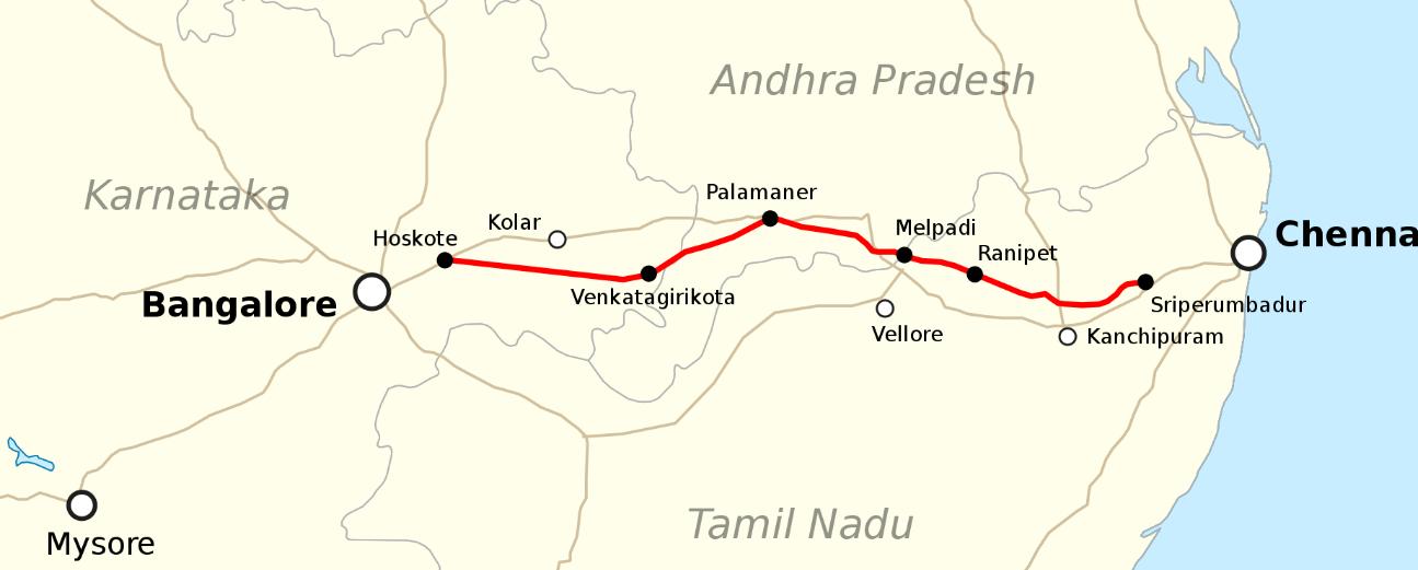
The Bengaluru-Chennai Expressway, also known as National Expressway 7 (NE-7), is a monumental infrastructure project currently underway, set to transform connectivity between two bustling South Indian cities: Bengaluru, the capital of Karnataka, and Chennai, the capital of Tamil Nadu. This ambitious venture spans a distance of approximately 258 kilometers (160 miles) and is envisioned as a 4-lane wide, access-controlled expressway, aimed at significantly reducing travel time and enhancing transportation efficiency between these key metropolitan hubs.
Stretching from Hoskote in the Bengaluru Metropolitan Region Development Authority to Sriperumbudur in the Chennai Metropolitan Area, the expressway is poised to serve as a vital artery for regional mobility, catering to a diverse array of commuters, cargo, and commercial traffic. With a targeted operational speed of 120 kilometers per hour (75 mph), the expressway promises to facilitate swift and seamless journeys, thereby bolstering economic growth and fostering closer ties between these dynamic urban centers.
The designation of the Bengaluru-Chennai Expressway as a National Expressway on 1 January 2021 underscores its strategic importance within India's broader transportation network. With a total project value estimated at ₹ 17,930 crore, this undertaking represents a significant investment in bolstering the country's infrastructure backbone, poised to yield long-term dividends in terms of enhanced connectivity, economic development, and regional integration.
Anticipated to be completed before the end of 2025, the expressway's progress marks a monumental stride towards realizing the vision of efficient, modern transportation infrastructure in South India. Despite earlier projections by the National Minister for Road Transport and Highways, Nitin Gadkari, the project's timeline underscores the complexities and scale of such endeavors, requiring meticulous planning, execution, and coordination among various stakeholders.
Furthermore, the Bengaluru-Chennai Expressway is not just a conduit for vehicular traffic; it catalyzes urban development and economic growth along its route. Key intersection points such as Mepladi in Vellore district and Ponapanthangal in Ranipet district are poised to emerge as major hubs for transfers and commercial activities, presenting opportunities for real estate development, industrial clusters, and necessary services.
Bangalore-Vijayawada Expressway
The Bengaluru-Vijayawada Expressway project (NH-544G) spans a distance of 518 kilometers, traversing through the states of Karnataka and Andhra Pradesh. This ambitious undertaking, forming part of Bharatmala Pariyojana (BMP) Phase 2, aims to create a 4-6 lane partially access-controlled highway, blending brownfield-upgrade and greenfield construction methodologies.
With an estimated cost of Rs. 19,320 crores, the project encompasses both familiar and new terrain, boasting a total length of approximately 624 kilometers. Notably, the greenfield section, stretching from Kodikonda to Addanki covering 332 kilometers, marks a significant stride in expanding the region's transportation infrastructure.
Characterized by a design speed of 120 kmph and a generous right of way measuring 100 meters, the Bengaluru-Vijayawada Expressway is poised to redefine travel efficiency and safety standards in the region. Under the stewardship of the National Highway Authority of India (NHAI), the project is currently under construction, with all civil construction contracts awarded in March 2023.
The project is delineated into three distinct sections:
1. Brownfield Upgrade: NH-44 from Bengaluru, Karnataka to Kodikonda, Andhra Pradesh, spanning 73 kilometers.
2. Greenfield Section: From Kodikonda to Addanki, covering a distance of 343 kilometers, representing a new frontier in highway development.
3. Brownfield Upgrade: NH-16 from Addanki to Vijayawada, spanning 113 kilometers, aimed at enhancing existing infrastructure to meet modern demands.
Each section is meticulously designed, with proposed lane widths of 3.75 meters and well-planned shoulders measuring either 3 meters paved or 2 meters unpaved, alongside a 19.50-meter depressed median.
The route of the expressway promises to connect key towns and villages along its path, including Kodikonda, Pulivendula, Mallepally, Vangapadu, Addanki, Chilakaluripet, Guntur, and ultimately, Vijayawada. This strategic alignment not only fosters regional connectivity but also opens up avenues for economic growth and social development across the corridor.
Nagpur- Hyderabad- Bengaluru Expressway
The Nagpur-Hyderabad-Bengaluru Expressway, alternatively referred to as the Nagpur-Bengaluru Expressway, stands as a transformative proposal set to revolutionize travel between the cities of Nagpur, Hyderabad, and Bengaluru. Envisioned as a sprawling 1,100-kilometer (680-mile) greenfield access-controlled expressway, this ambitious project aims to seamlessly connect the bustling urban centers of Maharashtra, Telangana, Andhra Pradesh, and Karnataka.
With its proposed six-lane design, the expressway promises to significantly enhance connectivity and efficiency, reducing both travel time and distance. Anticipated to slash the current 24-hour journey to a mere 12 hours, and spanning a shorter distance of approximately 1,100 kilometers (680 miles) compared to the existing 1,200 kilometers (750 miles), this expressway is poised to redefine regional transportation dynamics.
Comprising two distinct sections-one from Nagpur to Hyderabad and the other from Hyderabad to Bengaluru-the expressway will traverse diverse landscapes and regions, facilitating smoother inter-state travel and fostering economic integration.
Operated and maintained by the esteemed National Highways Authority of India (NHAI), the project represents a significant investment in infrastructure development, with an estimated cost of ₹35,000 crore (US$ 4.2 billion). With a projected completion target before 2030, the expressway is poised to unlock new opportunities for trade, commerce, and connectivity across the heartlands of central and southern India.
Pune-Bengaluru Expressway
The Pune-Bengaluru Expressway stands as an ambitious endeavor poised to transform connectivity between two bustling metropolises, Pune in Maharashtra and Bengaluru in Karnataka. Envisioned as a sprawling 700-kilometer-long, 8-lane Greenfield access-controlled expressway, this project is slated to become a cornerstone of the Bharatmala Pariyojana initiative.
Traversing through a total of 12 districts-three in Maharashtra and nine in Karnataka, the expressway promises to streamline travel and enhance economic integration across the region. By significantly reducing the distance between Pune and Bengaluru by approximately 95 kilometers, the project aims to slash travel time from the current 15 hours to a mere 7 hours upon completion.
At Pune, the expressway will seamlessly integrate with the Pune-Mumbai Expressway, further enhancing regional connectivity and facilitating smoother inter-city travel. Designed to operate parallel to National Highway 48, this Greenfield Expressway is envisioned as an alternative and faster route to the existing NH-48, catering to the growing demands of commuters and cargo alike.
Under Phase-II of the Bharatmala project, this expressway represents a monumental investment in infrastructure development, with an estimated cost of ₹50,000 crore. Starting from Kanjle on the proposed Pune ring road, the expressway traverses through Pune district, Satara district, and Sangli district in Maharashtra before crossing over into Karnataka.
In Karnataka, the expressway winds its way through Belagavi, Bagalkot, Gadag, Koppal, Vijayanagara, Davanagere, Chitradurga, Tumakuru, and Bengaluru Rural district, culminating at Muthagadahalli on the proposed Satellite ring road in the Bengaluru Metropolitan Region.
Electronic City Elevated Expressway
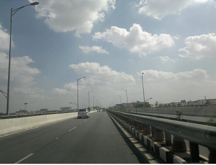
The Electronic City Elevated Expressway, spanning a length of 9.985 kilometers (6.204 miles), serves as a vital artery connecting the Silk Board junction to Electronic City in Bangalore, India. Part of the Bengaluru Elevated Tollways Ltd (BETL) project under the National Highways Development Project and Elevated Highways Project, it was conceived in early 2006 and officially inaugurated on 22 January 2010.
Beginning from Roopena Agrahara after the Central Silk Board flyover, the expressway extends up to Electronic City, soaring above the BMIC flyover at an impressive height of 17 meters (56 feet). Notably, it stands as the tallest flyover in Bangalore, enhancing the city's skyline while streamlining traffic flow to the tech hub of Electronic City.
The construction of the elevated expressway has significantly reduced commute times, offering a smoother and more efficient route for travelers. In conjunction with this project, the Bruhat Bengaluru Mahanagara Palike and Bangalore Development Authority have also planned a series of flyovers and underpasses along the arterial Hosur road to create a signal-free corridor, further enhancing traffic management and easing congestion.
Within Electronic City, the expressway features three exits, facilitating seamless access to various phases and neighboring areas. These exits include one directing towards Electronic City Phase 1 on the right side with both upward and downward ramps, a second exit leading to Electronic City Phase 2 on the left side with a downward ramp, and a third exit providing a straight path towards Hosur on NH 44 with ramps for both upward and downward traffic.
National Highways
National highways serve as the backbone of a country's road network, connecting major cities, ports, and economic centers across vast distances. These primary arterial routes play a crucial role in interstate and international trade, facilitating the movement of goods, services, and people. National highways are typically well-maintained and equipped with essential amenities to support long-distance travel, making them vital conduits for commerce, transportation, and national integration.
National Highway 44
National Highway 44 (NH 44) stands as a monumental artery traversing the length of India from its northern reaches to the southern tip, earning its distinction as the longest national highway in the country. Spanning an impressive 4,112 kilometers (2,555 miles), NH 44 charts a course through diverse landscapes and regions, serving as a vital conduit for both commerce and connectivity.
Originating from the picturesque city of Srinagar in the Union Territory of Jammu and Kashmir, NH 44 embarks on its journey southward, meandering through the states of Punjab, Haryana, Delhi, Uttar Pradesh, Rajasthan, Madhya Pradesh, Maharashtra, Telangana, Andhra Pradesh, Karnataka, and finally culminating at the southernmost point of Kanyakumari.
The genesis of NH 44 is a tale of amalgamation, as it emerged from the merging of seven distinct national highways, each contributing to its rich tapestry. From the historic Jammu-Srinagar National Highway (formerly NH 1A) to the bustling thoroughfares of Delhi and Agra, NH 44 encapsulates the essence of India's diverse topography and cultural mosaic.
Noteworthy is the recent transformation of a pivotal section, the Delhi-Panipat Expressway, which underwent a remarkable upgrade, transforming into an elevated tolled expressway boasting eight main lanes and four service lanes. This modernization endeavor, completed in July 2023 at a cost of ₹2,178.82 crores, signifies the ongoing efforts to enhance infrastructure and streamline transportation along NH 44.
Functioning as the backbone of the North-South Corridor under the National Highways Development Project (NHDP), NH 44 serves as more than just a thoroughfare; it embodies the aspirations of a nation on the move, facilitating trade, travel, and connectivity across vast expanses.
From the snow-capped peaks of the Himalayas to the sun-kissed shores of the Indian Ocean, NH 44 bears witness to the myriad hues and contours of India's landscape, weaving together the fabric of a nation united in its diversity, aspirations, and journey towards progress.
National Highway 275
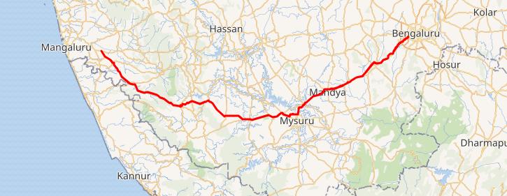
National Highway 275 (NH-275), widely recognized as the Bengaluru-Mysuru Access-Controlled Expressway, forms a critical component of the Bengaluru-Mangaluru Economic Corridor (EC-34), a pivotal transportation route facilitating connectivity and commerce in southern India.
This national highway originates from the bustling metropolis of Bengaluru, extending through the historic city of Mysore as a remarkable 10-lane expressway spanning 119 kilometers (74 miles). Beyond Mysore, the highway transitions into a 4-lane road leading towards Bilikere, ultimately terminating at Bantwal, thereby linking the coastal city of Mangalore to Bengaluru and serving as a significant bypass route for National Highway 75 (NH-75).
The transformative impact of the Bengaluru-Mysuru Access-Controlled Expressway is evident in its ambitious design, featuring a 10-lane elevated access-controlled carriageway. This modern infrastructure marvel, constructed at a cost of ₹8,000 crore, was meticulously developed in two phases to ensure seamless connectivity and enhanced transportation efficiency.
Phase-1, covering a stretch of 56 kilometers (35 miles) from Bengaluru to Nidaghatta, laid the foundation for this monumental project. Subsequently, Phase-2 extended over 61 kilometers (38 miles), connecting Nidaghatta to Mysore, further bolstering the region's transportation network.
The commencement of this project marked a significant milestone in March 2018, symbolizing a commitment to fostering economic growth, reducing travel time, and improving connectivity between Bengaluru and Mysore. By upgrading the highway from 4 to 10 lanes, with a primary focus on an elevated access-controlled carriageway complemented by service roads, the expressway aims to drastically reduce travel time from Bengaluru to Mysore from 3 hours to a mere 75 minutes, ushering in a new era of efficiency and convenience for commuters.
National Highway 75
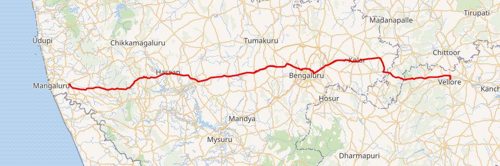
National Highway 75 (NH 75) holds a significant place among India's major National Highways, serving as a crucial lifeline that spans across the states of Karnataka, Andhra Pradesh, and Tamil Nadu. Formerly known as National Highway 48 (NH-48) before a renumbering exercise in 2010, this arterial road connects the bustling port city of Mangaluru (Mangalore) in the west to the historic city of Vellore in the east.
NH-75 emerges as a vital conduit for travelers, particularly those journeying from Mangaluru to Bengaluru and Hassan, facilitating smooth and efficient transportation across diverse landscapes. Traversing through the varied geographical regions of Karnataka-Karavali, Malenadu, and Bayaluseeme- this highway embodies the rich tapestry of the state's cultural and natural heritage.
Commencing its journey from Bantwal in Karnataka, NH-75 navigates through key towns and landmarks such as Nellyadi, Shiradi Ghat, Sakleshpur, Hassan, Yediyur, Kunigal, Bengaluru, Kolar, Mulbagal, Venkatagirikota, Pernambut, Gudiyattam, and Katpadi before reaching its terminus at Vellore in Tamil Nadu.
One of the notable features of NH-75 is its bypass routes around major urban centers like Hassan and Kunigal, ensuring smoother traffic flow and reducing congestion within city limits. This strategic planning enhances both the efficiency and safety of travel along the highway, further underscoring its importance as a vital artery of connectivity in southern India.
National Highway 844
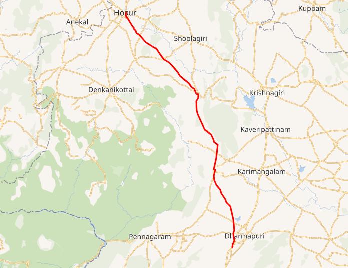
National Highway 844, known as NH 844, is a significant national highway in India, serving as a secondary route to National Highway 44. Stretching from Neraluru Thirumagondanahalli Village near Shri Ramana Maharshi Ashram in Bengaluru, Karnataka, NH 844 extends to Dharmapuri district in Tamil Nadu.
This vital highway links Neraluru village in Bengaluru, Karnataka, and traverses through Upkar Spring Fields layout, connecting to Hosur and Adiyamankottai in Dharmapuri, Tamil Nadu. As a key artery of transportation, NH 844 plays a crucial role in facilitating connectivity and accessibility between these regions, contributing to economic growth and social integration.
National Highway 48
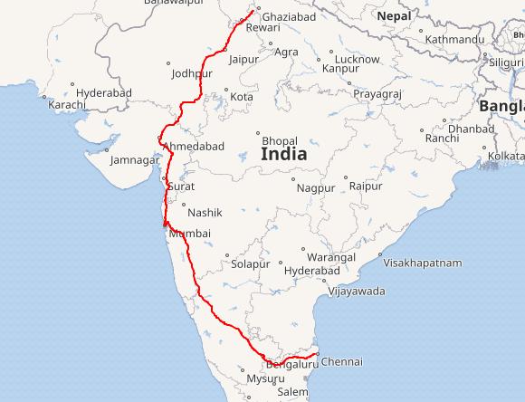
National Highway 48 (NH 48) stands as a pivotal artery of India's national highway network, stretching from Delhi to Chennai and traversing through seven states, covering a total distance of 2807 kilometers (1744 miles). This major thoroughfare passes through the states of Delhi, Haryana, Rajasthan, Gujarat, Maharashtra, Karnataka, and Tamil Nadu, connecting key cities and towns along its route.
Formerly designated as NH 8 from Delhi to Mumbai and NH 4 from Mumbai to Chennai, NH 48 emerged following the renumbering of national highways in 2010. Notably, the stretch between Pune and Bengaluru was historically referred to as P.B. Road.
NH 48 weaves through a tapestry of urban centers, industrial hubs, and cultural landmarks, facilitating seamless connectivity and fostering economic development across the region. From the bustling streets of Delhi and Gurugram to the vibrant cityscape of Mumbai and the historic charm of Chennai, NH 48 encompasses a diverse array of locales, each contributing to the fabric of India's cultural and economic landscape.
Along its journey, NH 48 passes through several prominent cities and towns, including Jaipur, Ahmedabad, Surat, Mumbai, Pune, Bengaluru, and Chennai. Notable stops include Ajmer, Udaipur, Vadodara, Belgaum, Hubli, Davanagere, Tumkur, and Kanchipuram, among others, underscoring the highway's significance as a lifeline for millions of travelers and businesses alike.
National Highway 948
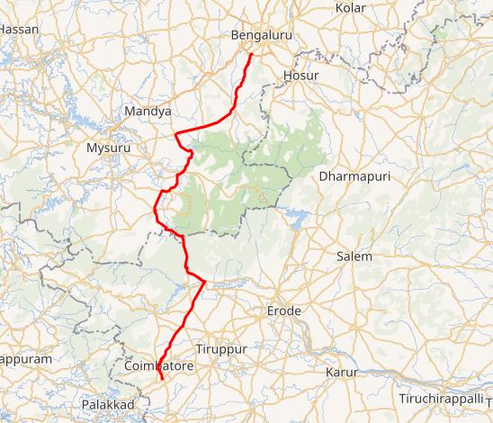
National Highway 948, previously known as NH 209, serves as a crucial link between Coimbatore in Tamil Nadu and the bustling city of Bengaluru in Karnataka. This highway, a branch of National Highway 48, carves its way through the picturesque landscape, traversing the scenic Sathyamangalam Wildlife Sanctuary.
As a vital lifeline connecting two major urban centers, NH 948 offers travelers a glimpse of nature's splendor as it winds its way through the Sathyamangalam forests. However, traversing this route comes with its own unique challenges, as the road through the wildlife sanctuary remains a single carriageway with two lanes, often narrow in certain sections. Moreover, the presence of wild animals adds to the allure of the journey, but also necessitates caution from travelers.
One notable aspect of NH 948 is the restriction on vehicular movement through the Dhimbam ghat stretch, specifically from Bannari to Karappallam, between 8 pm to 6 am. This measure is implemented to ensure the safety of both travelers and wildlife inhabiting the area.
It's worth mentioning that the Sathyamangalam forests, through which NH 948 passes, hold historical significance as the former territory of the notorious bandit Veerappan.
National Highway 766
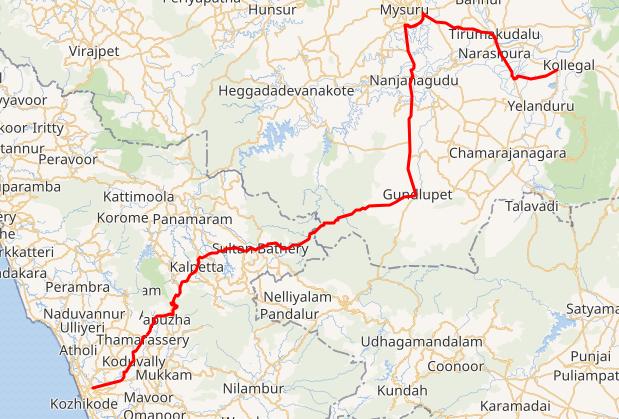
National Highway 766 (NH 766), previously known as NH-212, stands as a crucial lifeline connecting the cities of Kozhikode in Kerala to Kollegal in Karnataka via Mysore. Spanning a total distance of 272 kilometers, with 117 kilometers in Kerala and 155 kilometers in Karnataka, this highway plays a pivotal role in facilitating inter-state connectivity in Southern India.
Traversing through the verdant landscapes of the Western Ghats, NH 766 offers travelers a captivating journey through nature's bounty. The highway winds its way through dense forests, including the renowned Bandipur National Park and Wayanad Wildlife Sanctuary, providing glimpses of the region's rich biodiversity.
One of the highlights of NH 766 is the picturesque stretch from Lakkidi in Wayanad to Adivaram (Thamarassery), famously known as Thamarassery Churam. This scenic route, characterized by nine hairpin bends, offers a mesmerizing drive amidst breathtaking vistas.
In Kerala, NH 766 passes through key towns and settlements such as Kozhikode, Kunnamangalam, Koduvally, Thamarassery, Vythiri, Kalpetta, Sultan Bathery, and Muthanga. Upon crossing into Karnataka, the highway traverses through Gundlupet, Begur, Nanjangud, Mysore, T Narsipur, and finally culminates at Kollegal, where it joins National Highway 948, linking Bengaluru and Coimbatore.
State Highways
State highways, managed by state governments, provide essential connectivity within a particular state or region. While not as extensive as national highways, state highways play a vital role in intrastate travel, linking towns, cities, and rural areas within the state. These roadways support local transportation needs, facilitating economic development, tourism, and regional connectivity. State highways contribute to the overall accessibility and mobility within a state, enhancing transportation infrastructure and fostering socio-economic growth at the local level.
State Highway 85 (Karnataka)
State Highway 85 (SH-85) stands as a vital thoroughfare linking the vibrant city of Bengaluru in Bangalore Urban district to the quaint village of Jalsoor in Dakshina Kannada, within the scenic expanse of Karnataka, South India. With a sprawling length of 346.28 kilometers (215.17 miles), SH-85 holds the distinction of being one of the longest state highways in Karnataka, traversing through eight diverse districts.
This highway plays a pivotal role in regional connectivity, serving as one of the primary lifelines between Bengaluru and Dakshina Kannada, alongside NH-75 and NH-275/SH-88. Along its route, SH-85 meanders through a tapestry of towns and villages, each contributing to the rich cultural and geographical fabric of Karnataka.
From the bustling streets of Srigandha Kaval and Magadi Road in Bengaluru to the serene landscapes of Jalsoor, SH-85 winds its way through a myriad of locales, including Sunkadakatte, Kadabagere, Thavarekere, Magadi, Nagamangala, Somwarpet, Kukke Subramanya, and many more.
Under the ambit of the Karnataka State Highways Improvement Project (KSHIP-III), significant enhancements are underway to upgrade SH-85, transforming it into a modern roadway capable of accommodating increasing traffic demands. From Somwarpet to Magadi, the highway is being expanded into a two-lane carriageway, while the stretch from Magadi to Bengaluru is slated for a four-lane carriageway, ensuring smoother and safer journeys for commuters.
State Highway 17 (Karnataka)
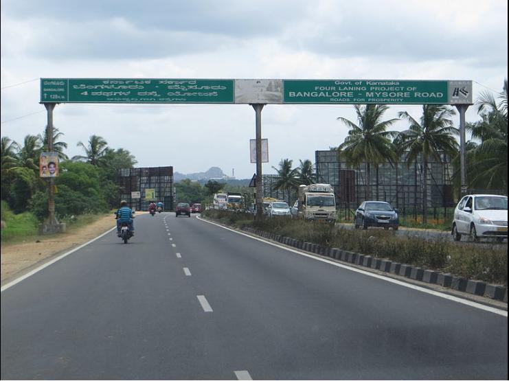
State Highway 17 (SH-17) serves as a vital artery connecting the bustling cities of Bangalore and Mysore in the southern Indian state of Karnataka. Spanning a total length of 149 kilometers (93 miles), this highway has played a significant role in enhancing regional connectivity and facilitating economic growth since its inauguration in 2003, managed by the Karnataka Road Development Corporation Limited.
Traversing through the vibrant towns of Ramanagara, Channapatna, Maddur, Mandya, and Srirangapatna (Seringapattinam), SH-17 offers commuters a smooth dual carriageway journey over the majestic Kaveri river. Notably, the 15-kilometer stretch from Bangalore Central to Kengeri NICE Road Junction is famously known as Mysore Road, serving as a lifeline for commuters between the two cities.
To meet the growing demands of traffic and ensure seamless travel experiences, several sections of SH-17 have undergone significant upgrades. The 62-kilometer Bangalore-Maddur section was enhanced under a build-operate-transfer (Annuity) model by a consortium of NCC Infra and Maytas Infra. Similarly, the 49-kilometer Maddur-Mysore stretch underwent improvements under an engineering, procurement, and construction (EPC) contract by Soma.
In a major development, the Bengaluru-Mysore highway was incorporated into the National Highways Authority of India (NHAI) network in 2014, becoming part of the Bengaluru-Bantwal NH-275. This upgrade transformed the highway into a 6-lane partially access-controlled thoroughfare, complemented by 2-lane service roads on either side, heralding a new era of enhanced connectivity and efficiency.
State Highway 35 (Karnataka)
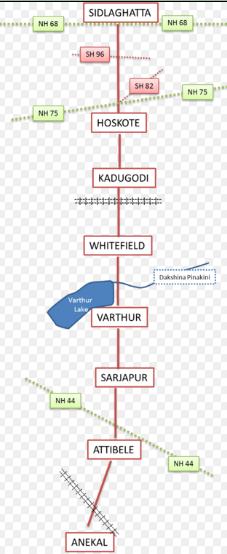
State Highway 35, commonly known as the Sidlaghatta-Anekal Highway, is a vital state thoroughfare spanning from Sidlaghatta in the north to Anekal in the south, traversing key locales such as Hoskote, Kadugodi, Whitefield, Varthur, Gunjur, Sarjapur, and Attibele. While a segment of the highway is maintained by the Karnataka Public Works Department, another portion falls under the purview of the Bruhat Bengaluru Mahanagara Palike.
Primarily a two-lane road, SH 35 boasts a four-lane stretch between Kadugodi and Varthur-Kodi, enhancing traffic flow and accessibility in this bustling corridor. Beginning its journey at NH 68 (formerly NH 234) in Sidlaghatta, the highway heads southward, intersecting with SH 82 and NH 75 (formerly NH 4) at Hoskote.
Continuing its trajectory, the highway crosses the Bangalore-Chennai Railway line at Kadugodi, intersecting with Whitefield Road and Varthur Road in the heart of Whitefield. Progressing further, it traverses over the Dakshina Pinakini (Ponnaiyar River) at Varthur-Kodi, meandering past Varthur Lake and the town of Varthur.
At Dommasandra, SH 35 intersects with Sarjapur Road before proceeding southward to Attibele, where it intersects with Hosur Road (NH 44, previously NH 7). From there, the highway veers southwest, crossing the Bangalore-Hosur Railway line, culminating its journey at Anekal.
State Highway 90 (Karnataka)
State Highway 90, also referred to as SH-90, is a vital state thoroughfare linking Hunsur in Mysuru (Mysore) to Talakaveri in Kodagu district, Karnataka. Spanning a total distance of 122.45 kilometers (76.09 miles), this highway serves as a crucial lifeline for residents and travelers in the region.
Traversing through picturesque landscapes and vibrant settlements, SH-90 connects several major towns and villages along its route. These include Hunsur, Kallahalli, Hunasegala, Muthurayana Hosalli, Manugana Halli, Karnakuppe, Panchavalli, Allur, Muddanahalli, Ane Chowkur, Mathigodu (Elephant Camp), Thithimathi, Gonikoppal, Virajpet, Nariyandada, Kakkabbe, Kunjila, Napoklu, Ballamavati, Bhagamandala, and finally, Talakaveri.
Notably, State Highway 90 serves as more than just a link between south Kodagu and Mysuru district. It also acts as a vital connector between Kannur district of Kerala and major cities like Mysuru and Bengaluru, facilitating regional connectivity and enhancing economic activities across the area.
Conclusion
To conclude, the infrastructure of expressways, national highways, and state highways connecting Bengaluru represents more than just a network of roads; it symbolizes the city's aspirations and its commitment to progress. As Bengaluru continues to evolve as a global hub of innovation and opportunity, these transportation corridors serve as lifelines, facilitating the movement of goods, people, and ideas across the region. From the ambitious projects like the Bengaluru-Chennai Expressway to the crucial arteries like National Highway 44, each roadway contributes to the city's growth story, fostering connectivity, economic development, and regional integration. As Bengaluru embarks on its journey towards a brighter future, its transportation infrastructure stands as a testament to its resilience, adaptability, and unwavering spirit of advancement.
explore further
Latest from Editorials
More from Publications
Resources


Dwello, for every home buyer, is a way to go from 'I feel' to 'I know', at no extra cost.