


Table of Contents
- Coastal Road (Mumbai)
- Key Points of Coastal Road Project
- Eastern Express Highway
- Key Facts About Eastern Express Highway
- Eastern Freeway
- Key Points of Eastern Freeway
- Western Express Highway
- Key Points of Western Express Highway
- Jogeshwari Vikhroli Link Road (JVLR)
- Sion Panvel Highway
- Key Points of Sion-Panvel Highway
- Mumbai - Pune Expressway
- Key Points of Mumbai-Pune Expressway
- Mumbai-Nagpur Expressway
- Key Points of Mumbai-Nagpur Expressway
- National Highways that pass through Mumbai
- National Highway 4 (NH 4)
- Old National Highway 6 (NH 6)
- Old National Highway 8 (NH 8)
- National Highway 9 (NH 9)
- Faq's
Mumbai one of the most important cities of India pulsates with life and energy which has been fueled by a web of highways that take you to the farthest reaches of its urban landscape. These roads or arteries of connectivity not only link diverse neighborhoods of Mumbai but also serve as lifelines for the millions who navigate its bustling streets daily.
From the Eastern Express Highway (EEH) to the Western Express Highway (WEH) and the iconic Mumbai-Pune Expressway, each roadway weaves a narrative of movement, progress, and connectivity.
As Mumbai evolves and expands, so too does its infrastructure. The proposed underground network project heralds a new era of innovation in traffic management, promising smoother journeys and reduced congestion on these arterial routes. Our article explores some of the biggest highways and National Highways of Mumbai, their key points, the regions these roads cover, and a route map.
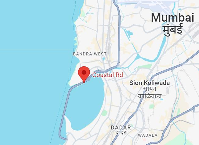
Coastal Road (Mumbai)
The Mumbai Coastal Road Project (MCRP) is a massive infrastructure initiative born out of the necessity to address the ever-increasing traffic congestion and connectivity challenges in Mumbai. As a city that serves as the commercial and financial heart of India, Mumbai attracts millions of people, leading to a dense urban landscape and a strain on existing transportation systems.
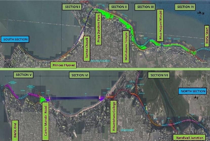
Phase 1 of the project, currently under construction, spans approximately 10.58 km and is focused on the southern section between Marine Drive and the Bandra Worli Sea link. This phase is a feat of an engineering marvel as it involves reclaiming land from the sea to create an 8-lane expressway that will significantly enhance the connectivity between South Bombay and Bandra.
Phase 2, a critical part of the project, will extend the coastal road further north, covering approximately 19 km to connect Bandra with Kandivali. The 9.6 km Bandra-Versova Sea Link (VBSL) project, awarded to the APCO Infratech-Webuild JV, plays a pivotal role in this extension. This ambitious phase will significantly reduce travel times between these regions and unlock new avenues for development and growth.
Map of Coastal Road, Mumbai
Key Points of Coastal Road Project
Length: Approximately 9.98 kilometers.
Location: Along the western coastline of Mumbai.
Purpose: To provide a coastal route connecting South Mumbai to the western suburbs, reducing travel time and congestion.
Lanes: Initially proposed to have 8 lanes.
Start Point: Princess Street Flyover in Marine Lines.
End Point: Kandivali.
Interchanges: Expected to have interchanges at various points along the route.
Connectivity: Enhances accessibility to major areas like Nariman Point, Bandra, Juhu, and Versova.
Timeline: Construction began in 2018, with phased completion expected.
Cost: Estimated at around Rs12,000 crore.
Also Read: Mumbai Coastal Road Project: The Next Big Thing For Real Estate
Eastern Express Highway
The Eastern Express Highway (EEH) in Mumbai spans 23.55 kilometers, serving as a vital transportation link between Chhatrapati Shivaji Maharaj Terminus and the major suburbs of North Mumbai. With six lanes, this highway is a crucial connector to National Highway 3 and plays a pivotal role in the transportation network of Mumbai. At the RCF junction (Priyadarshini), the Eastern Express Highway intersects with the Sion-Panvel Highway, extending its reach to the surrounding areas of Mumbai, commonly known as Dr Ambedkar Road.
Managed by the Mumbai Metropolitan Region Development Authority (MMRDA), the EEH undergoes regular maintenance and improvement efforts. Functioning as a key artery of Mumbai, the Eastern Express Highway facilitates travel between the island city, eastern suburbs, and the metropolitan area of Thane.
Like its counterpart, the Western Express Highway, both routes serve the north-south direction of the city, sometimes running parallel to each other. These highways have significantly alleviated traffic congestion on other roadways and areas, making commuting more efficient for residents and visitors alike.
Map of Eastern Express Highway
Key Facts About Eastern Express Highway
Here are some key facts about the Eastern Express Highway (EEH) in Mumbai:
Length: 23.55 kilometers making it one of the longest highways in Mumbai.
Location: Stars at Chhatrapati Shivaji Maharaj Terminus (CSMT) in South Mumbai and extends to North Mumbai.
Lanes: Total of six lanes, allowing for smooth traffic flow in both directions.
Connectivity: It serves as a crucial link connecting Mumbai to National Highway 3
Intersections: The Sion-Panvel Highway intersects the Eastern Express Highway at the RCF junction (Priyadarshini), further extending connectivity to the surrounding areas of Mumbai
Management: The Mumbai Metropolitan Region Development Authority (MMRDA) is responsible for the maintenance and improvement of the Eastern Express Highway.
Traffic: Due to its significance as a transportation route, the Eastern Express Highway experiences heavy traffic, particularly during rush hours.
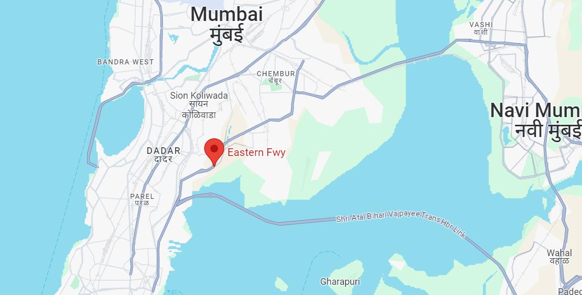
Eastern Freeway
The Eastern Freeway, officially named the Vilasrao Deshmukh Eastern Freeway, is a notable highway in Mumbai covering a distance of 16.8 kilometers. This high-speed expressway, constructed by the Mumbai Metropolitan Region Development Authority (MMRDA), stretches from Orange Gate near P D Mello Road to the Eastern Express Highway in Ghatkopar.
Financed by the Central Government under the Jawaharlal Nehru National Urban Renewal Mission (JnNURM), the Eastern Freeway features nine entry-exit ramps for convenient access. Notably, the freeway is equipped with seismic arresters capable of withstanding earthquakes up to 7.5 on the Richter scale, ensuring safety for the significant volume of vehicles that traverse it daily, even during late hours.
The success of this project has spurred the MMRDA to contemplate its extension. A planned 14-kilometer extension from Ghatkopar to Thane, along with the addition of four more entry-exit ramps, is in consideration, further enhancing connectivity and convenience for commuters in the region.
Map of Eastern Freeway
Key Points of Eastern Freeway
Length: The Eastern Freeway spans approximately 16.8 kilometers.
Route: It runs from Orange Gate near P D Mello Road to the Eastern Express Highway in Ghatkopar.
Construction: Built by the Mumbai Metropolitan Region Development Authority (MMRDA).
Financing: Funded by the Central Government under the Jawaharlal Nehru National Urban Renewal Mission (JnNURM).
Entry-Exit Ramps: The freeway features nine entry-exit ramps for convenient access.
Safety Measures: Equipped with seismic arresters capable of withstanding earthquakes up to 7.5 on the Richter scale.
Usage: Experiences a significant volume of traffic throughout the day and night.
Extension: Plans for a 14-kilometer extension from Ghatkopar to Thane are under consideration, along with the addition of four more entry-exit ramps.
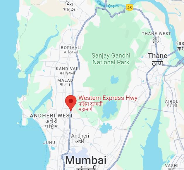
Western Express Highway
The Western Express Highway in Mumbai, stretching approximately 25 kilometers, is a vital arterial road that plays a pivotal role in the transportation network of Mumbai.
Recently, plans have been set in motion to alleviate the perennial congestion on this crucial highway by constructing a 15.3-kilometer elevated corridor using cable-stayed bridges. This ambitious project, estimated to cost around Rs 5,500 crore, aims to enhance traffic flow from Mahim to Dahisar, providing a seamless commute for vehicles along this busy route. The elevated section will feature three to four single-pier cable-stayed bridges, connected to underpasses at key junctions, promising a significant upgrade to the infrastructure of Western Express Highway.
Named after the former governor of Maharashtra, Nawab Ali Yavar Jung, the Western Express Highway holds historical significance beyond its role as a transportation artery. This road, extending from Bandra to Dahisar and further linking the western suburbs to the Mumbai-Delhi National Highway 8, honors the legacy of Nawab Ali Yavar Jung, a distinguished diplomat and statesman. His contributions to beautifying the highway and his vision for an impressive city entrance from the airport have left a lasting mark on the urban landscape of the city.
Map of Western Express Highway
Key Points of Western Express Highway
Length: The Western Express Highway spans approximately 25 kilometers.
Route: It runs from Bandra in the south to Dahisar in the north.
Construction: Built to facilitate faster connectivity between the suburbs and the city center.
Importance: Serves as a major arterial road in Mumbai, connecting important areas like Bandra, Andheri, Goregaon, and Dahisar.
Lanes: Comprises multiple lanes in both directions to accommodate heavy traffic flow.
Interchanges: Features various entry and exit ramps at strategic points along the route.
Landmarks: Passes by prominent landmarks such as the Bandra-Worli Sea Link, Jogeshwari-Vikhroli Link Road, and the Sanjay Gandhi National Park.
Commercial Hub: Surrounding areas along the Western Express Highway have witnessed significant commercial and residential development.
Public Transportation: Served by various modes of public transportation including buses and the Mumbai suburban railway network.
Traffic Congestion: Experiences heavy traffic congestion, particularly during peak hours.
Maintenance: Regularly maintained by the Mumbai Metropolitan Region Development Authority(MMRDA) to ensure smooth functioning and safety for commuters.
Jogeshwari Vikhroli Link Road (JVLR)
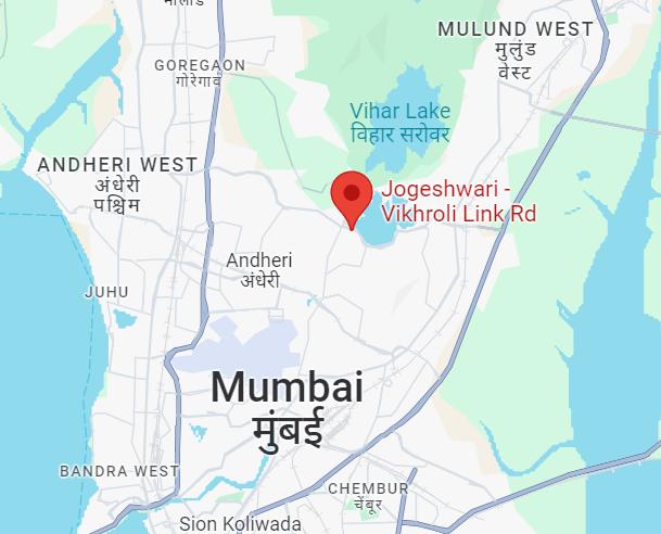
Now, this is not a highway but JVLR is one of the important roads in Mumbai as it serves as a crucial central median route connecting the Western Express Highway and the Eastern Express Highway, providing a vital link between the western and eastern suburbs.
Initially opened in 1994 to offer faster access from Jogeshwari to Vikhroli, the 10.6km stretch of JVLR at present is ongoing construction work for Metro Line 6. The elevated line being built along JVLR is a 14.4km project by the Mumbai Metropolitan Regional Development Authority (MMRDA) aimed at reducing travel time between the Eastern and Western Express Highways by 35-45 minutes, with an initial cost of Rs 6,716 crore.
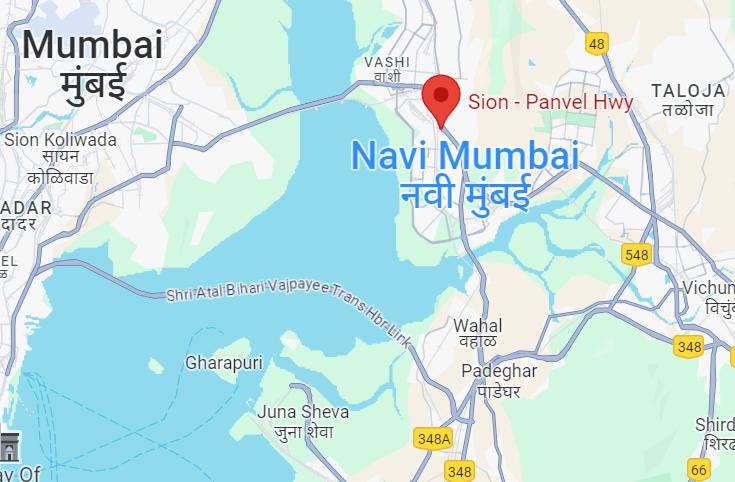
Sion Panvel Highway
The Sion Panvel Highway, a vital 25 km expressway in Maharashtra, serves as a crucial link connecting Sion in Mumbai to Panvel via Navi Mumbai. This significant roadway, managed by the Maharashtra State Road Development Corporation, Maharashtra Public Works Department, and Municipal Corporation of Greater Mumbai, plays a pivotal role in enhancing connectivity between major cities like Mumbai, Navi Mumbai, and Panvel.
The highway not only facilitates smoother travel between these urban centers but also serves as a gateway for vehicles traveling towards Mumbai from regions like Konkan and Goa. With its strategic location and importance in the Mumbai Metropolitan Region (MMR), the Sion Panvel Highway stands as a key infrastructure artery supporting the economic activities and daily commutes of the region.
Map of Sion - Panvel Highway
Key Points of Sion-Panvel Highway
Length: The Sion-Panvel Highway spans approximately 40 kilometers.
Route: It connects Sion in Mumbai to Panvel in the Raigad district.
Importance: Serves as a crucial transportation corridor, linking Mumbai with the extended suburbs and neighboring regions.
Connectivity: Provides connectivity to major areas like Chembur, Vashi, and Nerul.
Commercial Hub: Surrounding areas along the Sion-Panvel Highway have witnessed significant commercial and residential development.
Interchanges: Features various entry and exit ramps at strategic points along the route.
Lanes: Comprises multiple lanes in both directions to accommodate heavy traffic flow.
Public Transportation: Served by various modes of public transportation including buses and the Mumbai suburban railway network.
Traffic Congestion: Experiences heavy traffic congestion, particularly during peak hours.
Maintenance: Regularly maintained by the Maharashtra State Road Development Corporation (MSRDC) to ensure smooth functioning and safety for commuters.
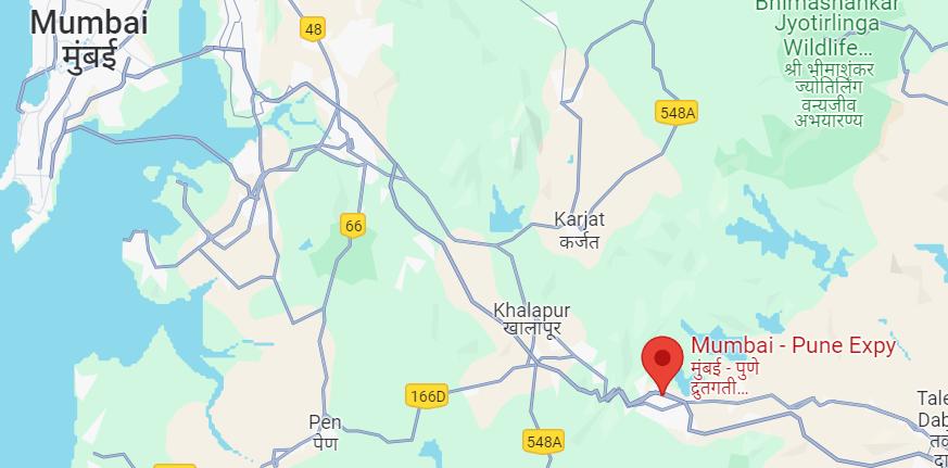
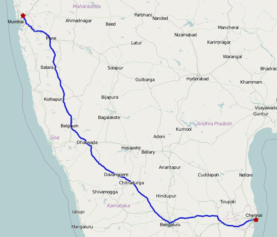
Mumbai - Pune Expressway
The Yeshwantrao Chavan Mumbai-Pune Expressway stands as a pioneering fully operational access-controlled toll road. This six-lane high-speed expressway serves as a vital link between Mumbai, the financial capital, and Pune, the cultural capital of Maharashtra. Renowned for its scenic beauty and picturesque hill stations along the route, traveling on this expressway offers a delightful experience.
Covering a distance of approximately 168 kilometers from Andheri in Mumbai to Deccan in Pune, the expressway enables travelers to complete the journey in less than three hours, bypassing the usual intercity crossroads and traffic light interruptions.
Map of Mumbai-Pune Expressway Route
Key Points of Mumbai-Pune Expressway
Length: The Pune-Mumbai Expressway spans approximately 94.5 kilometers, making it one of the longest expressways in India.
Route: It connects Pune, a major city in Maharashtra, to Mumbai, the financial capital of India. The expressway starts at Pune and terminates at Kalamboli near Mumbai.
Importance: Serving as a vital transportation corridor, the Pune-Mumbai Expressway plays a crucial role in linking two major cities and facilitating the movement of goods and people between them.
Connectivity: The expressway provides seamless connectivity to major areas such as Pune, Lonavala, Khandala, and Mumbai, enhancing accessibility and reducing travel time between these regions.
Commercial Hub: Surrounding areas along the Pune-Mumbai Expressway have witnessed significant commercial and residential development, further highlighting its importance as an economic corridor.
Interchanges: The expressway features various entry and exit ramps at strategic points along the route, allowing for easy access to adjacent areas and enhancing convenience for commuters.
Lanes: Comprising multiple lanes in both directions, the Pune-Mumbai Expressway accommodates heavy traffic flow, ensuring smoother and faster travel between Pune and Mumbai.Public Transportation: The expressway is served by various modes of public transportation, including buses and private taxis, providing additional options for commuters traveling between Pune and Mumbai.
Traffic Congestion: While the Pune-Mumbai Expressway offers faster travel compared to traditional routes, it experiences heavy traffic congestion, particularly during peak hours, due to the high volume of vehicles using the route.
Maintenance: Regular maintenance of the Pune-Mumbai Expressway is carried out by the Maharashtra State Road Development Corporation (MSRDC) to ensure its smooth functioning and safety for commuters, highlighting the importance of infrastructure upkeep for efficient transportation networks.
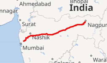
Mumbai-Nagpur Expressway
The Samruddhi Mahamarg, also known as the Nagpur-Mumbai Expressway, officially named Hindu Hrudaysamrat Balasaheb Thackeray Maharashtra Samruddhi Mahamarg, and Maharashtra Expressway-2 (ME-2), is a significant infrastructure project underway in Maharashtra, India.
Spanning a length of 701 kilometers, it is one of the longest greenfield road initiatives in India. This access-controlled expressway, currently operational with six lanes expandable to eight, aims to connect the two capital cities, Mumbai and Nagpur.
Led by the Maharashtra State Road Development Corporation (MSRDC), the project was created to deliver fast logistics gateway for national and international trade, the expressway will connect the largest container port of India i.e JNPT in Mumbai to Mihan in Nagpur.
The expressway will allow access to several industrial and economic corridors through 24 interchanges at strategic locations. It will widely connect the Delhi-Mumbai Industrial Corridor, Bengaluru-Chennai Economic Corridor, Western Dedicated Freight Corridor, Eastern Dedicated Freight Corridor, Chennai-Vizag Economic Corridor and Golden Quadrilateral. Apart from JNPT other seaports including Kandla MBPT, Mormugao, New Mangalore, Kochi, Chennai, Visakhapatnam and Ennore will also have indirect connectivity.
The Nagpur-Aurangabad-Mumbai Highway is a critical transportation link connecting the cities of Nagpur and Aurangabad with the state capital, Mumbai. This highway, primarily traversing along NH6, offers significant advantages to commuters, enabling them to save approximately 65 kilometers in distance compared to alternative routes. Moreover, travelers experience a considerable reduction in total travel time, typically taking around one-and-a-half hours less to reach their destination. The efficiency of the highway in shortening travel distances and times underscores its importance in facilitating smoother and more expedient journeys between these major urban centers in Maharashtra.
Map of Mumbai-Nagpur Expressway Route
Key Points of Mumbai-Nagpur Expressway
Length: Spans a total length of 701 kilometers, making it one of the longest expressways in India.
Connectivity: It connects the two major cities of Maharashtra, Nagpur and Mumbai, serving as a vital transportation corridor between the capital and its third-largest city.
Lane: Initially operational with six lanes, the expressway is built to accommodate future expansion to eight lanes, catering to increasing traffic demands.
Economic Impact: The expressway is expected to have a significant economic impact by facilitating faster movement of goods and people between Nagpur and Mumbai, thereby boosting trade, commerce, and tourism along the corridor.
Led by MSRDC: The project is spearheaded by the Maharashtra State Road Development Corporation (MSRDC), underscoring the commitment of the state government to infrastructure enhancement and regional connectivity.
National Highways that pass through Mumbai
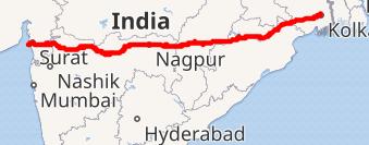
Old National Highway 3 (NH 3)
Source - Wikipedia
National Highway 3, also known as Old NH 3, the length of the old NH 3 was 1,190 km. The highway originated in Agra in Uttar Pradesh, generally travelled southwest through Dholpur in Rajasthan, Morena, Gwalior, Shivpuri, Guna, Biaora, Maksi, Dewas, Indore and Julwania in Madhya Pradesh, and Dhule, Malegaon, Nashik, Thane and terminated at Mumbai.
The stretch between Agra and Gwalior was marked as the North-South corridor by the National Highways Authority of India. After it entered Bombay, the highway was known as Eastern Express Highway. The stretch from Mumbai to Nashik became Mumbai Nashik Expressway.
Since the National Highway Authority of India renumbered all national highways in 2010, the former NH 3 has been broken into several new highway numbers, and the old NH 3 has been canceled.
National Highway 4 (NH 4)
Source: Wikipedia
Old National Highway 4, designated as NH 4, is a vital highway that stretches over 1,235 kilometers, connecting Mumbai in Maharashtra to Chennai in Tamil Nadu. This highway passes through states like Karnataka and Andhra Pradesh, serving as a key corridor for transportation and trade between the western and southern regions of India. NH 4 is known for its strategic importance in linking major cities like Pune, Bangalore, and Chennai, playing a crucial role in the economic development and connectivity of these urban centers.
NH 4 forms a significant portion of the Mumbai to Chennai segment within the Golden Quadrilateral project, encompassing about 90% of this crucial corridor.
Over the years, NH 4 has undergone extensive upgrades, transforming from a two-lane single carriageway to a modern four-lane dual carriageway.
In Karnataka, NH 4 is locally referred to as the Pune-Bangalore (PB) Road. Notably, the Mumbai to Pune section of NH 4 saw a substantial enhancement with the introduction of the Mumbai-Pune Expressway in 2000, further easing traffic congestion and enhancing connectivity between these key cities. NH 4 travels through densely populated towns and cities across Maharashtra, Karnataka, Tamil Nadu, and Andhra Pradesh, including Pune, Satara, Belgaum, Hubli, Bangalore, Kanchipuram, and Sriperumbudur.
To mitigate traffic congestion along the Bangalore-Chennai stretch, plans were laid out by the National Highways Authority of India (NHAI) for the construction of the Bangalore-Chennai Expressway, allowing for higher speeds of up to 120 km/h.
The NH 4 by-passed Pune from Dehu Road to Katraj. The Pune bypass has 4 lanes. There is a partial service lane which cannot be called as motorable.
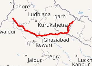
Old National Highway 6 (NH 6)
National Highway 6, or NH 6, is a significant highway in India that spans approximately 1,949 kilometers. Please note the number of the highway has been changed and each section has been given a different number. Hajira to Deogarh section is part of new National Highway No. 53, Deogarh tp Kharagpur section is part of new National Highway No. 49, Kharagpur to Kolaghat to Kolkata section is part of new National Highway No. 16.
It is also known as Asian Highway 46 (AH46), Mumbai-Kolkata Highway, and Great Eastern Highway.
This highway connects Hazira in Gujarat to Kolkata in West Bengal, passing through states like Maharashtra, Chhattisgarh, and Odisha. NH 6 serves as a crucial link between the western and eastern regions of India, facilitating the movement of goods and people across multiple states. It plays a vital role in enhancing connectivity and trade between major cities like Nagpur, Raipur, and Kolkata, contributing to the economic growth and development of these regions.
Old National Highway 8 (NH 8)
National Highway 8 (NH 8), now part of NH48, is a crucial 4-lane (6-lane in most sections) highway in India, renowned as the busiest thoroughfare on the subcontinent. Spanning approximately 1428 kilometers, NH 8 serves as a vital link connecting the national capital Delhi to the financial hub Mumbai, along with several key cities such as Gurgaon, Jaipur, Ajmer, Udaipur, Ahmedabad, Vadodara, Surat, Nadiad, Anand, and Kheda.
As a pivotal component of the Golden Quadrilateral project initiated by the National Highways Authority of India (NHAI), NH 8 was among the first sections to be completed. This highway encompasses significant expressways like the Delhi-Gurgaon Expressway, Jaipur-Kishangarh Expressway, and Ahmedabad Vadodara Expressway.
In Mumbai, NH 8 traverses through numerous suburbs along the western line of the Mumbai Suburban Railway, earning the moniker Western Express Highway as it approaches downtown Mumbai.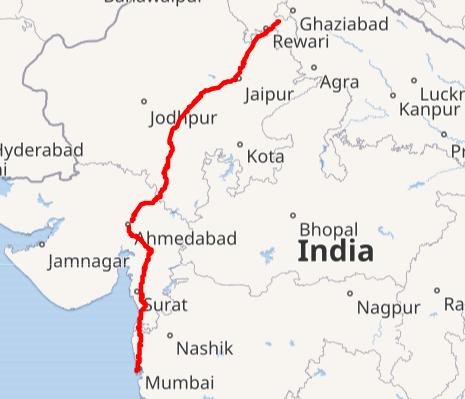
National Highway 9 (NH 9)
National Highway 9 (NH 9) is a significant east-west corridor in India, stretching from Malout in Punjab to Pithoragarh district in Uttarakhand. This vital highway traverses through the states of Punjab, Haryana, Delhi, Uttar Pradesh, and Uttarakhand, connecting various key regions along its route. After the renumbering of national highways by the National Highway Authority of India in 2010, NH 9 was formed by amalgamating segments of five distinct national highways.
These include the Old NH 10 (Fazilka-Delhi section), Old NH 24 (Delhi-Rampur section), Old NH 87 (Rampur-Rudrapur section), Old NH 74 (Rudrapur-Sitarganj-Khatima section), and Old NH 125 (Tanakpur-Pithoragarh section).
In conclusion, the intricate network of highways originating from Mumbai serves as the lifeline of the city, facilitating seamless connectivity not only within Mumbai but also with neighboring regions and major cities across India. From the iconic Mumbai-Pune Expressway to the ambitious Nagpur-Mumbai Expressway and the historical National Highways like NH 4 and NH 8, each roadway tells a story of progress, development, and economic vitality.
These highways have not only reduced travel times and congestion but have also spurred economic growth, facilitated trade, and enhanced accessibility to various parts of the country. The ongoing infrastructure projects, such as the Coastal Road Project, Eastern Freeway, and Mumbai-Nagpur Expressway, promise to further revolutionize transportation in the region, ushering in a new era of efficiency, safety, and connectivity.
explore further
Latest from Editorials
More from Publications
Resources


Dwello, for every home buyer, is a way to go from 'I feel' to 'I know', at no extra cost.