


Table of Contents
- Introduction to NH7 Haryana to Uttarakhand
- Route Overview and Key Cities
- Places to Visit Along the Way
- Infrastructure Development Along NH 7 (Haryana to Uttarakhand)
- Future Development and Expansion Plans
- Conclusion
- Faq's
Introduction to NH7 Haryana to Uttarakhand
National Highway 7 is a significant route in India, connecting various states and facilitating efficient transportation. In particular, the stretch of NH7 that connects Haryana to Uttarakhand is crucial for both commercial and travel purposes. The highway runs through diverse terrains and regions, linking urban and rural areas and contributing to the economic development of both states. Starting from Haryana, NH7 traverses a path that showcases the transition from the plains of Haryana to the more hilly and scenic landscapes of Uttarakhand. This route not only serves as a lifeline for trade and commerce, providing crucial connectivity for goods transportation but also attracts numerous tourists heading to the picturesque hill stations and pilgrimage sites in Uttarakhand.
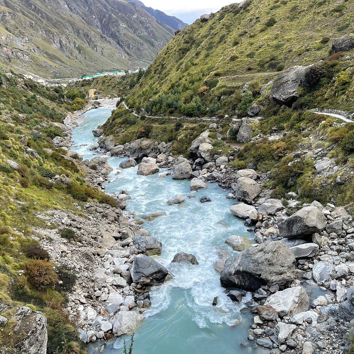
The journey along NH7 is marked by varied geographical features, which offer travelers an opportunity to experience a blend of cultures and environments. As one travels from Haryana, the flat agricultural lands gradually give way to the foothills of the Himalayas, characterized by lush green forests and fresh mountain air. Key towns along this route, such as Roorkee and Haridwar, serve as essential waypoints, offering amenities and services to travelers. Moreover, the presence of national parks and natural reserves along NH7 enhances its appeal as a popular travel corridor. For pilgrims, the proximity of holy sites like Haridwar adds a spiritual dimension to the journey. Ongoing infrastructure development further aims to improve the highway's capacity and safety, ensuring that it meets the growing demands of traffic. Overall, NH7 not only symbolizes a crucial artery of connectivity between Haryana and Uttarakhand but also stands as a gateway to exploring the rich cultural and natural heritage of northern India.
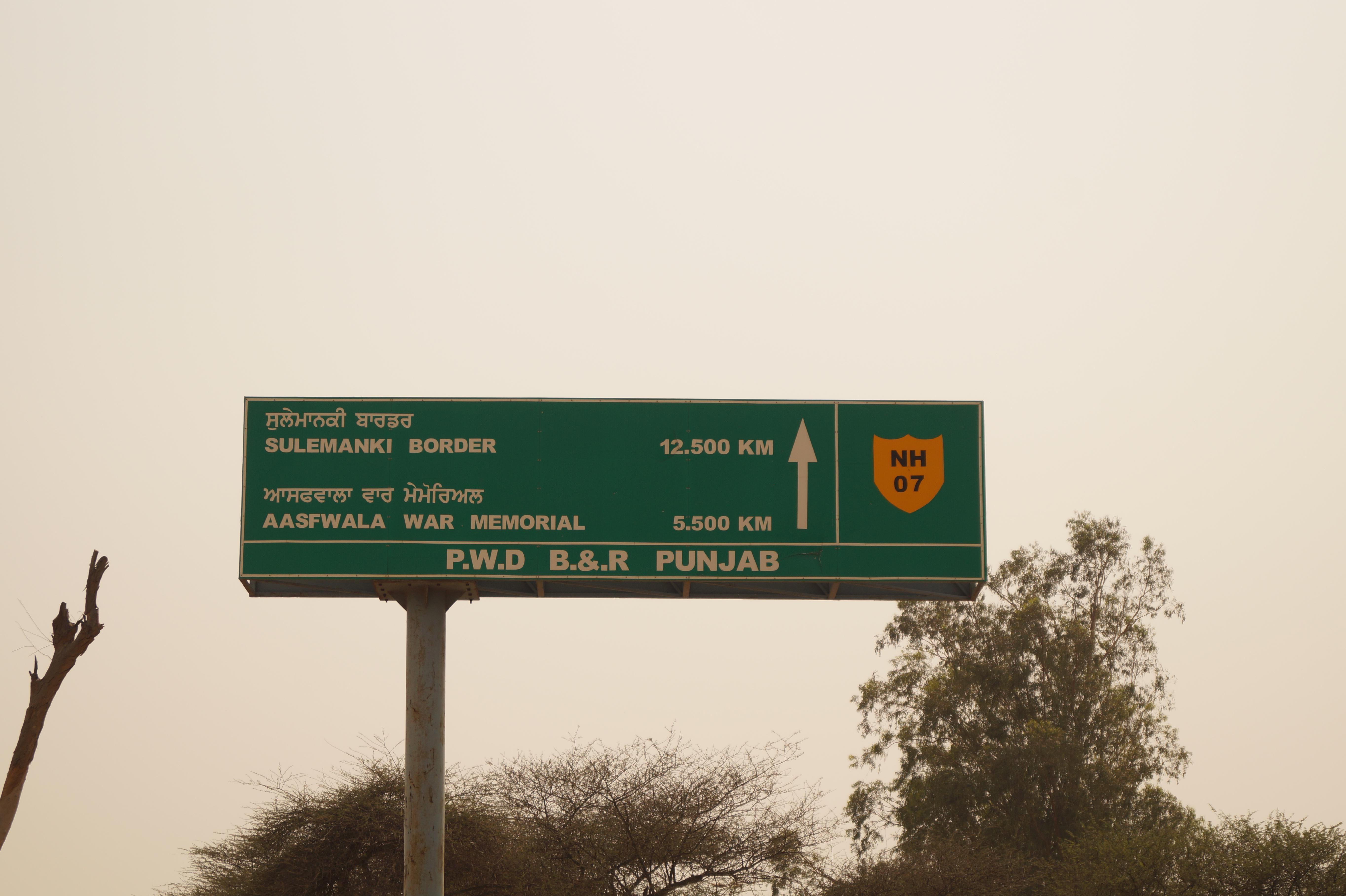
 Godigit, NH 7
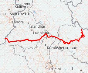
Route Overview and Key Cities
NH7, a significant national highway, connects Haryana to Uttarakhand, offering a vital transportation link between the plains and the hills. The route traverses through a diverse landscape, transitioning from the agricultural heartland of Haryana to the mountainous terrain of Uttarakhand. The journey presents a captivating blend of cultural experiences and scenic vistas. The highway facilitates the movement of goods, promotes tourism, and connects communities, playing a crucial role in the socio-economic development of the region. Understanding the key cities along this route provides valuable insights into the economic, cultural, and geographical significance of the area. The condition of NH7 varies, with stretches undergoing improvements and maintenance, highlighting the ongoing efforts to enhance connectivity and ensure smoother travel for commuters and tourists alike. As you travel along this route, anticipate varying road conditions and always prioritize safe driving practices, especially when navigating the hilly sections. Key cities along NH7 from Haryana to Uttarakhand include Yamunanagar in Haryana and Dehradun, Rishikesh, and Haridwar in Uttarakhand.
Yamunanagar, a prominent industrial city in Haryana, serves as a crucial transit point for travelers heading towards the hills. It is known for its plywood industry and is situated on the banks of the Yamuna River, offering a glimpse into the agricultural and industrial landscape of Haryana. Entering Uttarakhand, Haridwar, a significant religious city, is one of the first major destinations. Situated on the banks of the Ganges, it attracts millions of pilgrims annually and serves as a gateway to the Char Dham Yatra. Further along, Rishikesh, known as the "Yoga Capital of the World," offers a blend of spiritual and adventure tourism, with activities like rafting and trekking. Finally, Dehradun, the capital city of Uttarakhand, is an educational and administrative hub nestled in the Doon Valley, known for its pleasant climate, scenic beauty, and prestigious institutions. These cities not only serve as vital economic and cultural centers but also offer a diverse range of experiences for travelers exploring the NH7 route.
 Wikipedia, NH 7
Places to Visit Along the Way
Ram Jhula: Ram Jhula is a prominent iron suspension bridge located in Rishikesh, Uttarakhand, India. Spanning the Ganges River, it connects the neighborhoods of Muni Ki Reti and Swarg Ashram. Completed in 1986, the bridge is named after the revered saint Ram, symbolizing spiritual crossing and community connection. The structure is about 750 feet long and is a vital link for pedestrians and light vehicles, facilitating access to various ashrams, temples, and the surrounding areas famous for yoga and meditation. With its scenic backdrop of hills and flowing river, Ram Jhula is a significant tourist attraction, embodying both cultural and spiritual essence.
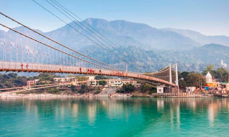 Ram Jhula, Exoticmiles
Mindrolling Monastery: Mindrolling Monastery, located in the Dehradun district of Uttarakhand, India, is one of the six major monasteries of the Nyingma tradition of Tibetan Buddhism. Founded in 1965 by the renowned Tibetan Buddhist master, the 16th Karmapa, and later established by the late Kyabje Penor Rinpoche, it serves as a vital spiritual and cultural center for Tibetan Buddhism. The monastery showcases intricate architecture and vibrant murals, reflecting rich Tibetan artistic traditions. It also houses a large collection of sacred texts, thangkas, and statues, emphasizing its importance as a place of worship, learning, and preservation of Tibetan culture and heritage.
 Mindrolling Monastery, Incredibleindia
Saraswati River: Saraswati River is a mythical river mentioned extensively in the ancient Hindu texts, the Vedas and Puranas. Once considered a mighty river flowing between the Yamuna and Sutlej, it is believed to have dried up thousands of years ago. Some identify it with the Ghaggar-Hakra river system, a seasonal river that flows through northwest India and Pakistan. Efforts are underway to revive the Saraswati, with researchers using satellite imagery and geological studies to trace its ancient course. For many Hindus, the Saraswati remains a sacred symbol of knowledge, wisdom, and purity, embodying the power of a life-giving and enlightening force.
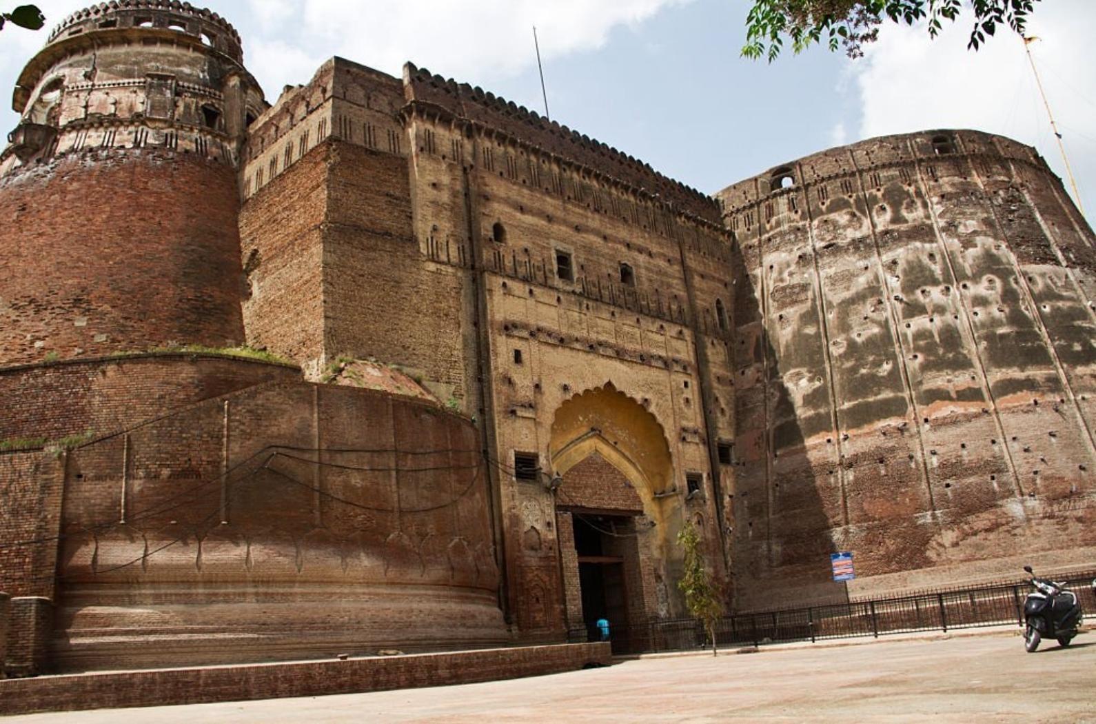
Qila Mubarak: Qila Mubarak, located in Patiala, Punjab, India, is a historic fortress that showcases the architectural brilliance of the 18th century. Commissioned by Maharaja Ala Singh in 1763, it served as the royal residence of the Patiala dynasty. The complex features remarkable structures like the Mubarak Hall and the Sheesh Mahal, adorned with intricate frescoes and mirror work. The fort's design reflects a blend of Mughal and Sikh architectural styles. Qila Mubarak is not only a symbol of regional heritage but also a testament to the rich history and culture of Punjab, attracting numerous visitors and historians alike.
Infrastructure Development Along NH 7 (Haryana to Uttarakhand)
Infrastructure development along National Highway 7 connecting Haryana to Uttarakhand has played a crucial role in strengthening regional connectivity, safety, and economic growth. Over the years, this highway corridor has witnessed consistent upgrades aimed at supporting rising traffic volumes, tourism demand, and inter-state trade movement. One of the major focus areas has been road widening and strengthening, where single and intermediate lanes have been improved into wider, well-paved carriageways to ensure smoother and faster travel. High-quality asphalt surfacing, improved shoulders, and better lane markings have significantly enhanced driving comfort and reduced vehicle wear and tear. Several stretches of NH 7 have also seen bridge rehabilitation and culvert modernization, ensuring uninterrupted movement even during heavy rainfall and seasonal flooding, which is especially important near the Uttarakhand border regions.
Another key aspect of infrastructure development along NH 7 is the emphasis on road safety and traffic management systems. Authorities have installed modern signage, reflective road studs, crash barriers, and guardrails, particularly in accident-prone and hilly stretches. Sharp curves and steep gradients near Uttarakhand entry points are now supported with proper warning systems, speed control measures, and improved visibility features. Street lighting has been added near towns, junctions, and busy intersections, enhancing night-time safety for commuters and freight operators. In addition, dedicated bus bays, pedestrian crossings, and service roads near populated areas have helped reduce congestion and improve overall traffic discipline along the highway.
Infrastructure growth along National Highway 7 has also encouraged the development of support facilities and roadside amenities. Fuel stations, rest areas, vehicle repair centers, logistics yards, and small commercial hubs have emerged along key stretches, benefiting both travelers and local communities. These facilities are particularly important for long-distance truck drivers and tourist vehicles traveling between Haryana and Uttarakhand. Improved drainage systems and slope stabilization work in sensitive zones have further strengthened the highway's durability and reduced maintenance disruptions. Together, these infrastructure improvements have transformed NH 7 into a more reliable, safer, and economically productive corridor, supporting tourism growth, industrial supply chains, and balanced regional development between Haryana and Uttarakhand.
Future Development and Expansion Plans
Widening and Strengthening Existing Carriageway: The initial phase of development for NH-7 likely involves widening the existing road and strengthening its pavement. This addresses immediate concerns regarding capacity and road quality. This will involve increasing the number of lanes on key sections of the highway, particularly those experiencing high traffic volume or bottlenecks. In many areas, NH-7 may currently be a two-lane road; expansion to four lanes or even six lanes in urbanized stretches significantly improves traffic flow and reduces congestion. Strengthening the pavement is crucial for handling the increasing load of commercial vehicles and heavy traffic. This includes using modern materials and construction techniques to ensure the road surface can withstand the stresses of heavy usage and varying weather conditions. Furthermore, improved drainage systems will be installed to prevent waterlogging and road damage during the monsoon season. The implementation of these improvements can significantly reduce travel time and the number of accidents. This also incorporates better shoulders and median barriers. This phase aims to provide a smoother, safer, and more durable road surface for current traffic demands while setting the stage for future upgrades. Surveys on traffic patterns and road conditions will likely dictate the precise sections chosen for immediate widening and strengthening.
Improving Safety Features and Implementing Traffic Management Systems: Beyond widening and strengthening, a significant focus will be on enhancing road safety and implementing modern traffic management systems. This involves installing better signage, road markings, and reflective delineators to improve visibility, especially during nighttime and adverse weather conditions. Crash barriers will be strategically placed along vulnerable sections of the highway, such as curves and embankments, to prevent vehicles from veering off the road. Furthermore, the implementation of advanced traffic management systems (ATMS) can play a crucial role in optimizing traffic flow and enhancing safety. This could involve installing CCTV cameras for real-time monitoring of traffic conditions, variable message signs (VMS) to provide drivers with up-to-date information on traffic delays and road closures, and automated traffic counters to collect data for planning and analysis. Another key aspect is the construction of underpasses and overpasses at major intersections and populated areas to separate local traffic from highway traffic, reducing the risk of accidents and improving traffic flow. Speed management measures, such as speed cameras and rumble strips, will also be implemented to discourage speeding and promote safer driving habits. Public awareness campaigns on road safety will be conducted to educate drivers and pedestrians on safe road practices.
Constructing Bypass Roads and Elevated Corridors: To alleviate congestion in towns and cities along the NH-7 corridor, the construction of bypass roads and elevated corridors are likely to be planned. Bypass roads divert traffic away from urban areas, reducing congestion and improving air quality in these areas. These bypasses provide a faster and more efficient route for long-distance travelers, reducing travel time and fuel consumption. Elevated corridors, or flyovers, are constructed over congested sections of the highway, providing a grade-separated route for through traffic. This eliminates the need for vehicles to stop at intersections, reducing traffic delays and improving overall traffic flow. The construction of these bypasses and elevated corridors requires careful planning and consideration of environmental and social impacts. Land acquisition can be a challenging process, and efforts must be made to minimize displacement and compensate affected communities fairly. Environmental impact assessments will be conducted to identify and mitigate potential environmental impacts, such as noise pollution and habitat loss. Sustainable construction practices will be adopted to minimize the environmental footprint of the project. These improvements are critical for enhancing the efficiency of NH-7 and ensuring its long-term viability as a major transportation artery. These types of projects usually involve longer planning and environmental impact assessment timelines.
Conclusion
National Highway 7, also known as NH 7, forms a vital transportation link between Haryana and Uttarakhand, facilitating the movement of goods and people. Spanning diverse landscapes, it enhances regional connectivity and economic opportunities, promoting tourism and trade. The highway plays a crucial role in the socio-economic development of the areas it traverses, ensuring better access to essential services. Continuous upgrades and maintenance are crucial for safety and efficiency, supporting the growing traffic demand. Ultimately, NH 7 is instrumental in fostering mobility and bridging cultural and economic ties between the two states.
explore further
Latest from Editorials
More from Publications
Resources


Dwello, for every home buyer, is a way to go from 'I feel' to 'I know', at no extra cost.