


Table of Contents
- Introduction
- Expressways
- Delhi-Gurugram Expressway
- Delhi-Faridabad Skyway
- Yamuna Expressway
- Delhi-Meerut Expressway
- Delhi Noida Direct Flyway
- National Highways
- National Highway 19
- National Highway 8
- National Highway 24
- National Highway 44
- National Highway 9
- Conclusion
- Faq's
Introduction
India's capital, Delhi, stands as a bustling metropolis at the heart of the nation, serving as a nexus of commerce, culture, and connectivity. Key to its vitality are the arteries of transportation that bind it to the rest of the country, facilitating the seamless movement of people and goods. Among these vital conduits are the National Highways, intricate networks of roads that not only connect Delhi to various corners of the nation but also serve as lifelines for economic growth and social cohesion.
In this comprehensive overview, we delve into the key National Highways that converge upon Delhi, exploring their significance, history, and impact on the region's transportation landscape. From the iconic Delhi Gurugram Expressway to the historic National Highway 19, each route weaves a tale of progress, connectivity, and the relentless pursuit of modernization.
Join us as we embark on a journey along these Expressways and National Highways, tracing their trajectories, unraveling their stories, and uncovering the vital role they play in shaping the socio-economic fabric of Delhi and beyond.
Expressways
Expressways, also known as freeways or motorways, are high-speed roads designed for rapid transit over long distances. They feature limited access with specific entry and exit points, allowing for uninterrupted traffic flow. Typically characterized by high speed limits, divided lanes, grade-separated intersections, and restricted access points, expressways efficiently handle large volumes of traffic and are vital components of modern transportation networks, facilitating swift and safe travel between urban centers and across regions.
Delhi-Gurugram Expressway
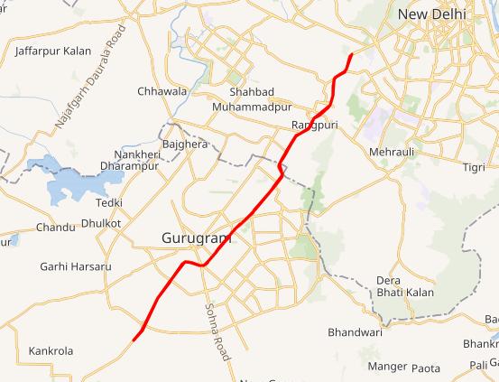
The Delhi Gurugram Expressway, a vital artery in India's transportation network, spans 27.7 kilometers (17.2 miles) and boasts six to eight lanes, facilitating seamless connectivity between the national capital, Delhi, and the bustling Millennium city of Gurugram, nestled in Haryana within the sprawling National Capital Region (NCR).
An integral segment of the esteemed Golden Quadrilateral project, which forms a cornerstone of the ambitious National Highway Development Project, this expressway stands as a testament to India's infrastructural prowess. With an estimated cost of ₹10 billion (US$125.2 million), the development of this brownfield expressway heralded a new era of efficient transportation.
The meticulous construction of the expressway unfolded in phases, culminating in its final section opening its lanes to commuters on January 23, 2008. Since then, it has emerged as the veritable lifeline of inter-city travel, bearing witness to a staggering daily traffic volume exceeding 180,000 Passenger Car Units (PCUs).
Embarking from the iconic Dhaula Kuan in Delhi, the expressway embarks on its journey, traversing through the bustling urban landscape before culminating on the outskirts of Gurugram, strategically positioned to accommodate the sprawling expanse of the city. Gurugram, a thriving metropolis in its own right, finds itself flanked on both sides by this critical artery, facilitating the seamless movement of people and goods alike.
Beyond its tangible utility, the Delhi Gurugram Expressway embodies the spirit of progress, acting as a conduit for economic growth and societal development. Its enduring legacy resonates through the bustling traffic it accommodates and the countless stories of journeys undertaken, underscoring its significance in the fabric of India's transportation infrastructure.
Delhi-Faridabad Skyway

The Delhi Faridabad Skyway (DF Skyway) stands as a remarkable feat of engineering, a 4.4-kilometer-long elevated highway boasting six lanes, serving as a crucial link between the bustling metropolis of Delhi and the vibrant city of Faridabad within the National Capital Region (NCR) of India. This vital artery was officially inaugurated on November 29, 2010, marking a significant milestone in the region's transportation infrastructure.
The ambitious project was brought to fruition through the endeavors of the concessionaire "Badarpur Faridabad Tollway Limited," a subsidiary of the esteemed Hindustan Construction Company Limited. From its inception, the DF Skyway was envisioned as not just a means of connectivity but a testament to India's commitment to modernizing its transportation networks.
Embarking from the vibrant locale of Badarpur in Delhi, near the DDA Flats Badarpur, the elevated highway unfolds its lanes majestically, offering commuters a seamless journey above the bustling streets below. Its trajectory leads southward, traversing through the urban landscape with unparalleled efficiency, until it gracefully descends upon Sector 37 in Faridabad, Haryana, in close proximity to the Sarai Metro station.
Beyond its immediate utility, the DF Skyway plays a pivotal role in the broader scheme of the National Highways Authority of India's (NHAI) North-South corridor, seamlessly integrating into the vast expanse of National Highway 44. This extensive corridor, stretching from the serene valleys of Srinagar to the southern tip of Kanyakumari, serves as a lifeline for interregional connectivity, fostering economic growth and social cohesion along its path.
The DF Skyway stands as a testament to human ingenuity, offering not just a passage between two cities but a conduit for progress and development. Its towering pillars and sleek lanes symbolize the aspirations of a nation marching confidently towards a future of boundless possibilities. As vehicles traverse its elevated expanse, they become part of a larger narrative of connectivity and advancement, embodying the spirit of a nation on the move.
Yamuna Expressway

The Yamuna Expressway stands as a monumental engineering marvel, a modern thoroughfare weaving through the Indian state of Uttar Pradesh with its expansive six-lane width, expandable to eight lanes, and stretching an impressive 165.5 kilometers (102.8 miles). Serving as a vital artery, it connects the burgeoning urban hub of Greater Noida with the historic city of Agra, seamlessly linking two major economic and cultural centers of the region.
This expressway emerged as a solution to alleviate the congestion plaguing the older Delhi-Agra national highway (NH-2), commonly known as Mathura Road, offering travelers a faster and smoother passage between these key destinations.
The realization of the Yamuna Expressway required a significant investment, amounting to ₹12,839 crore (US$1.6 billion), a testament to the scale and ambition of the project. On August 9, 2012, the expressway was unveiled to the public, symbolizing a leap forward in Uttar Pradesh's infrastructure development under the leadership of then Chief Minister Akhilesh Yadav.
Complementing the main thoroughfare are 13 service roads spanning approximately 168 kilometers, meticulously constructed to cater to the needs of local commuters, providing convenient access to adjoining areas while ensuring smooth flow on the expressway itself.
One of the most significant aspects of the Yamuna Expressway is its strategic connectivity. Plans are underway to integrate it seamlessly with the Eastern Peripheral Expressway through an interchange being constructed at Jaganpur Afzalpur village, near the esteemed Noida International University in the Gautam Budh Nagar district. This intersection not only enhances regional connectivity but also reinforces Uttar Pradesh's position as a key player in India's burgeoning transportation network.
Beyond its functional utility, the Yamuna Expressway serves as a symbol of progress and development, embodying the aspirations of a dynamic and forward-thinking society. It not only facilitates the movement of goods and people but also fosters economic growth, tourism, and regional integration, laying the groundwork for a brighter and more connected future for the region.
Delhi-Meerut Expressway

The Delhi-Meerut Expressway, also known as National Expressway 3, represents a transformative leap in India's transportation infrastructure, spanning a staggering 96 kilometers to connect the bustling capital city of Delhi with the vibrant city of Meerut via Dasna in Ghaziabad. This controlled-access expressway is a testament to India's commitment to modernizing its road networks to meet the demands of a rapidly growing economy and population.
A standout feature of this expressway is the remarkable widening of the 8-lane old stretch of National Highway 9 (NH-9) up to Dasna, now expanded to an impressive 14 lanes, making it the widest expressway in India. This expansion aims to alleviate congestion and enhance traffic flow along one of the busiest corridors in the National Capital Region (NCR).
The fourth phase of the Delhi-Meerut Expressway marks a significant milestone with the construction of a new alignment from Dasna to Meerut, encompassing a six-lane stretch that seamlessly integrates with the Meerut bypass. This phase is poised to further streamline connectivity between these two bustling urban centers, unlocking new opportunities for economic growth and regional development.
Notably, the 28-kilometer stretch between the iconic Nizamuddin Bridge and Dasna has long been recognized as one of the most congested areas in the NCR. The completion of the Delhi-Meerut Expressway promises to mitigate congestion and significantly reduce travel time, thereby improving the overall quality of life for commuters and residents alike.
The ambitious project comes with an estimated total cost ranging between ₹8,000-10,000 crores, underscoring the scale and importance of this endeavor in India's infrastructure landscape. Furthermore, ongoing efforts to extend the expressway with an additional 14-kilometer Package 5, currently under construction from Zainuddinpur to Jahidpur, highlight the government's continued commitment to enhancing connectivity and promoting economic development across the region.
As the Delhi-Meerut Expressway continues to take shape, it not only serves as a critical artery for transportation but also symbolizes India's aspirations for progress, prosperity, and seamless connectivity in the 21st century.
Delhi Noida Direct Flyway

The Delhi-Noida Direct Flyway, commonly referred to as the DND Flyway, stands as a pioneering marvel in India's infrastructure landscape. Spanning a length of 7.5 kilometers (4.7 miles), this access-controlled expressway boasts the distinction of being India's first 8-lane wide thoroughfare in the bustling Delhi National Capital Region (NCR).
Linking Maharani Bagh and Nizamuddin on the western side with Noida's Sector-15A and Mayur Vihar on the eastern banks of the Yamuna River, the DND Flyway serves as a vital artery, facilitating seamless connectivity and significantly reducing travel time between these prominent urban centers.
Operated and maintained by the Noida Toll Bridge Company Limited (NTBCL), a subsidiary of IL&FS, the DND Flyway operates on a build-own-operate-transfer (BOOT) basis, symbolizing a public-private partnership aimed at delivering efficient transportation solutions.
Constructed by the Japan-based Mitsui-Marubeni Corporation Ltd., the DND Flyway opened its lanes to the public in January 2001, marking a watershed moment in India's quest for modernized infrastructure. The expressway's main carriageway (MCW), stretching over 6.0 kilometers, includes a magnificent bridge traversing the majestic Yamuna River, while an additional 1.5 kilometers comprises the Mayur Vihar link (MVL), providing seamless connectivity to the eastern suburbs of Delhi.
Notably, the DND Flyway was inaugurated four months ahead of schedule on January 24, 2001, by the then Chief Minister of Uttar Pradesh, Rajnath Singh, in the esteemed presence of the Lt. Governor of Delhi, Vijai Kapoor, and the then Chief Minister of Delhi, Sheila Dixit. This early completion underscored the project's significance and the collective effort invested in its realization.
Furthermore, the junction of the DND Flyway and the Inner Ring Road at Maharani Bagh in Delhi holds a pivotal distinction-it serves as the starting point of India's longest expressway, the Delhi-Mumbai Expressway, signifying the DND Flyway's integral role in India's broader transportation network.
As a symbol of progress and connectivity, the DND Flyway continues to play a crucial role in easing traffic congestion, promoting economic growth, and enhancing the quality of life for millions of commuters traversing the bustling corridors of the Delhi NCR.
National Highways
National Highways are major roads designated by a country's government to connect important cities, regions, and economic centers. Serving as vital transportation arteries, they are characterized by their strategic significance, long-distance connectivity, high traffic volume, adherence to quality standards, government funding for maintenance, and often identified by a numbering system for navigation. These highways play a critical role in facilitating economic growth, commerce, and travel within a country's transportation network.
National Highway 19

National Highway 19 (NH 19), once recognized as the Delhi-Kolkata Road, stands as a vital lifeline in India's vast network of national highways. Renowned for its bustling thoroughfare and strategic significance, NH 19 holds a prominent position as one of the busiest arteries in the country, facilitating crucial connectivity between the national capital, Delhi, and the historic city of Kolkata.
Following the renumbering initiative spearheaded by the Ministry of Road Transport and Highways in 2010, NH 19 emerged as the designated route for travel between Agra and Kolkata, while the Delhi to Agra stretch assumed the mantle of National Highway 44. This reorganization not only streamlined the national highway system but also underscored the continued evolution and expansion of India's transportation infrastructure.
Formerly known as NH 2 (Old), NH 19 carries with it a rich legacy of facilitating trade, commerce, and cultural exchange across the length and breadth of the nation. Its historical significance dates back centuries, tracing the footsteps of countless travelers, merchants, and adventurers who traversed its path in pursuit of their dreams.
Spanning vast swathes of diverse terrain and traversing through states steeped in history and tradition, NH 19 embodies the spirit of India's unity in diversity. From the bustling streets of Delhi's urban sprawl to the serene landscapes of Uttar Pradesh, Bihar, Jharkhand, and West Bengal, the highway serves as a conduit for regional integration and economic growth.
As travelers journey along NH 19, they are met with a tapestry of sights and sounds that encapsulate the essence of India-from ancient monuments and bustling markets to verdant fields and bustling towns. The highway not only facilitates the movement of goods and people but also serves as a cultural corridor, fostering exchange and dialogue among diverse communities.
In an era marked by rapid urbanization and technological advancements, NH 19 remains a steadfast symbol of continuity and progress. Its continued relevance underscores the resilience and adaptability of India's transportation infrastructure, paving the way for a future characterized by enhanced connectivity, economic prosperity, and social cohesion.
National Highway 8

National Highway 8 (NH 8) stands as a vital lifeline in India's extensive road network, renowned for its crucial role in connecting the bustling national capital of Delhi with the vibrant financial hub of Mumbai. Spanning a total length of 1,428 kilometers, NH 8 traverses through some of the most important cities and economic centers in the country, including Gurgaon, Jaipur, Ajmer, Udaipur, Ahmedabad, Vadodara, Surat, Nadiad, Anand, and Kheda.
With estimates pegging it as the busiest highway in the subcontinent, NH 8 plays a pivotal role in facilitating the movement of goods and people across regions, fostering economic growth, and promoting cultural exchange. The highway, often referred to as the backbone of India's transportation infrastructure, serves as a vital artery connecting key urban centers and industrial hubs.
As part of the Golden Quadrilateral project initiated by the National Highways Authority of India (NHAI), NH 8 holds the distinction of being the first section to be completed. This ambitious initiative aimed to upgrade and modernize India's major highways, enhancing connectivity and reducing travel times between major cities.
Several expressways, including the Delhi-Gurgaon Expressway, Jaipur-Kishangarh Expressway, and Ahmedabad-Vadodara Expressway, form integral parts of NH 8, further bolstering its efficiency and capacity to handle heavy traffic volumes.
In its journey towards Mumbai, NH 8 traverses through nearly all the suburbs along the western line of the Mumbai Suburban Railway, earning the moniker "Western Express Highway." This stretch is emblematic of the highway's significance in Mumbai's urban fabric, serving as a crucial link between the city center and its sprawling suburbs.
Beyond its utilitarian function, NH 8 embodies the spirit of progress and connectivity, symbolizing India's aspirations for economic development and modernization. As vehicles ply its lanes, they become part of a larger narrative of growth and prosperity, contributing to the nation's journey towards a brighter future.
National Highway 24

National Highway 24 (NH 24) stands as a vital lifeline in the extensive network of India's national highways, coursing in a north-south trajectory entirely within the confines of the populous state of Uttar Pradesh. Its creation marked a pivotal moment in the evolution of the country's transportation infrastructure, a product of reimagining and restructuring, where the erstwhile routes of NH 29 and NH 97 were amalgamated and renumbered to form this arterial thoroughfare, aligning with the contemporary national highway numbering system.
Traversing through the heart of Uttar Pradesh, NH 24 bears witness to the rhythm of life in one of India's most populous states. From the vibrant streets of cities like Ghaziabad and Lucknow to the tranquil countryside dotted with villages, this highway encapsulates the essence of Uttar Pradesh's cultural diversity and economic vibrancy.
Moreover, NH 24 plays a pivotal role in driving economic growth and development across the region. As a primary artery for trade and commerce, it facilitates the movement of goods and services, linking industrial hubs, agricultural markets, and commercial centers. Its strategic importance extends beyond the boundaries of Uttar Pradesh, contributing to the overall connectivity and integration of the national transportation network.
As NH 24 continues to evolve and adapt to the changing needs of a dynamic society, its legacy as a cornerstone of India's transportation network remains steadfast, guiding countless journeys and shaping the narrative of progress in Uttar Pradesh.
National Highway 44
National Highway 44 (NH 44) stands as a pivotal north-south corridor within India's extensive network of national highways, earning the distinction of being the longest highway in the country.
Spanning a vast geographical expanse, NH 44 traverses through the Union Territory of Jammu and Kashmir, as well as the states of Punjab, Haryana, Delhi, Uttar Pradesh, Rajasthan, Madhya Pradesh, Maharashtra, Telangana, Andhra Pradesh, Karnataka, and Tamil Nadu, stitching together diverse regions and cultures along its route.
Its inception marked a significant milestone in India's transportation landscape, arising from the amalgamation of seven national highways, each contributing its segment to the grand tapestry of NH 44. Originating from the picturesque city of Srinagar in Jammu and Kashmir, the highway embraces the former NH 1A, meandering through the lush valleys before intertwining with former NH 1 in Punjab and Haryana, culminating at the heart of the nation, Delhi.
Further south, NH 44 amalgamates segments of former NH 2, navigating the bustling streets of Delhi before extending its reach to the historic city of Agra. From there, it traces the path of former NH 3, embarking on a journey through the heart of India, weaving its way past cultural landmarks and bustling cities, until it merges with former NH 7, leading to the southern tip of the subcontinent, Kanyakumari.
In the pursuit of continuous improvement and modernization, a notable section of NH 44, spanning from Delhi's Mubarka Chowk to Panipat, underwent a transformative upgrade. This stretch, colloquially known as the Delhi-Panipat Expressway, has been reimagined as an elevated, tolled expressway featuring eight main lanes and four service lanes. Completed in July 2023 at a cost of ₹2,178.82 crores, this upgraded section epitomizes India's commitment to enhancing its infrastructure and facilitating smoother, more efficient transportation for its citizens and businesses alike.
National Highway 9

National Highway 9 (NH 9) stands as a vital artery coursing through the heart of India in an expansive east-west trajectory. Its journey begins at the historic town of Malout in Punjab, a land steeped in rich cultural heritage, and extends all the way to the picturesque district of Pithoragarh in Uttarakhand, nestled amidst the majestic Himalayas.
Traversing through the diverse landscapes of Punjab, Haryana, Delhi, Uttar Pradesh, and Uttarakhand, NH 9 weaves together the fabric of these regions, facilitating seamless connectivity and fostering economic growth along its route.
The genesis of the current NH 9 dates back to the renumbering initiative undertaken by the National Highway Authority of India in 2010, which saw the amalgamation of segments from five distinct national highways. These included the historic Old NH 10, with its renowned Fazilka-Delhi stretch; the iconic Old NH 24, spanning from the bustling streets of Delhi to the enchanting town of Rampur; the scenic Old NH 87, meandering through the verdant landscapes from Rampur to Rudrapur; the bustling Old NH 74, which traverses through Rudrapur, Sitarganj, and Khatima; and the tranquil Old NH 125, offering a serene passage from Tanakpur to the picturesque Pithoragarh.
With each segment seamlessly integrated into the fabric of NH 9, the highway emerges as a lifeline for the regions it traverses, catering to the diverse needs of commuters, traders, and tourists alike. Its significance transcends mere transportation, serving as a catalyst for socio-economic development and cultural exchange.
As vehicles ply along its expanse, NH 9 embodies the aspirations of a nation on the move, forging new pathways of progress and prosperity. From the bustling streets of urban centers to the serene vistas of rural hinterlands, it stands as a testament to India's unwavering commitment to modernization and connectivity.
In its journey from Malout to Pithoragarh, NH 9 not only bridges geographical distances but also bridges the aspirations of millions, embodying the spirit of unity in diversity that defines the essence of India.
Conclusion
As we conclude our exploration of the key National Highways connecting to Delhi, it becomes evident that these arteries of transportation serve as more than mere conduits for vehicles; they are the lifeblood of connectivity, progress, and unity in the region. From the bustling Delhi-Gurugram Expressway to the historic National Highway 19, each highway embodies a legacy of development, linking urban centers, rural hinterlands, and cultural landmarks.
These highways not only facilitate the movement of goods and people but also act as catalysts for economic growth, fostering trade, commerce, and investment along their routes. Moreover, they serve as cultural corridors, connecting diverse communities and fostering social cohesion across regional boundaries.
As Delhi continues to evolve as a dynamic hub of activity and innovation, the importance of these National Highways only grows, underscoring the need for continuous investment, modernization, and expansion in India's transportation infrastructure. By embracing the challenges and opportunities presented by these vital arteries, Delhi and the surrounding regions can pave the way for a future defined by enhanced connectivity, prosperity, and sustainable development.
explore further
Latest from Editorials
More from Publications
Resources


Dwello, for every home buyer, is a way to go from 'I feel' to 'I know', at no extra cost.