


Table of Contents
- Introduction to Noida
- Noida Master Plan 2031 Map and PDF
- Key Goals of Noida Master Plan 2031
- Land Utilization in Noida
- Maximizing Land Potential in Noida for Sustainability
- Proposed Urban Land Use Strategy in Noida
- Population Growth Dynamics in Noida
- Population Density at Noida
- Land Use Planning Under Noida Master Plan 2031
- Distribution of Land Use: Noida Master Plan 2031
- What is Mixed Land Use?
- Planned Regional Transport Connections
- Planned Regional Railway Connections
- Metro Corridor
- Planned Regional Road Connections
- New Noida Master Plan 2041
- Conclusion
- Faq's
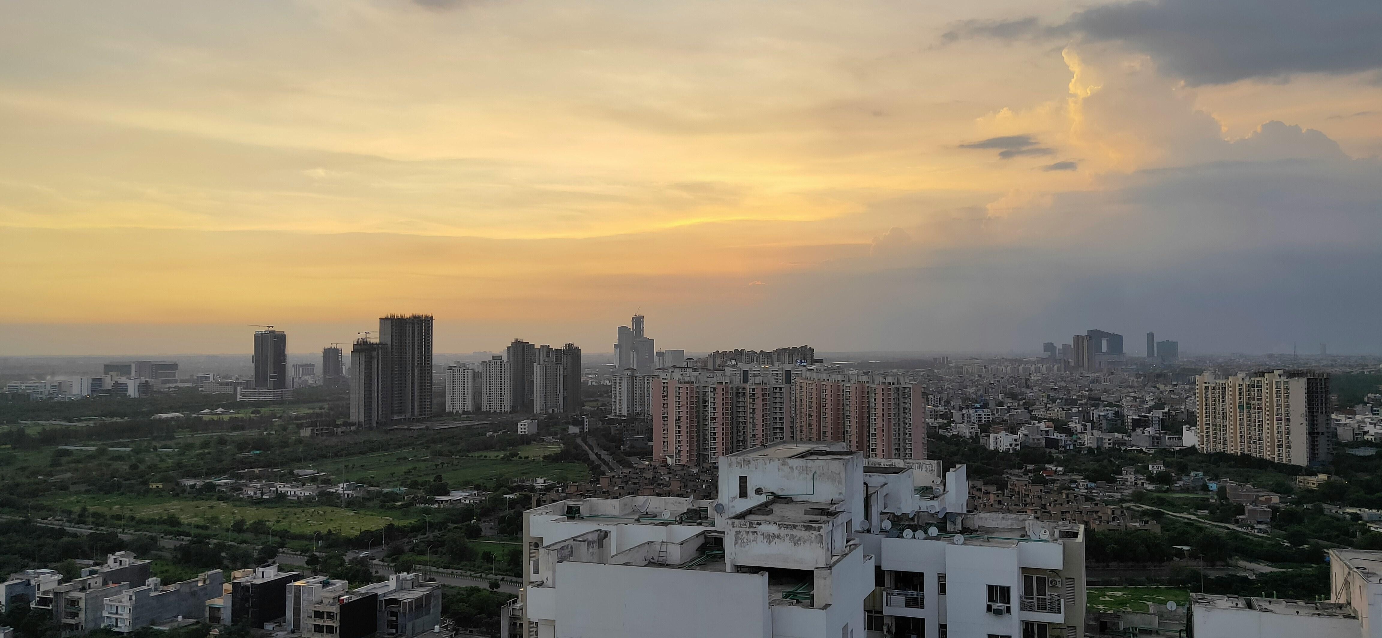
Introduction to Noida
Noida, originally derived from the abbreviation New Okhla Industrial Development Authority, is a vibrant city located in the Gautam Buddh Nagar district of Uttar Pradesh. As part of the National Capital Region (NCR) of India, Noida serves as a key economic and industrial powerhouse in the region. The administrative center of the district is located in the adjacent city of Greater Noida.
Over the years, Noida has emerged as a significant business and commercial hub, attracting both domestic and international companies across various industries. The city boasts a diverse range of businesses, including those in the automotive sector, energy and utilities, IT and ITES companies, as well as electronics manufacturing firms. This has contributed significantly to the economic growth and development of Noida, making it a sought-after destination for business investments.
One of the notable landmarks in Noida is Film City, a dedicated hub for news organizations and film studios. The presence of Film City has not only boosted the entertainment industry but has also put Noida on the map as a cultural and media center in North India. Additionally, Noida's strategic location near Delhi, the country's political capital, has further enhanced its prominence as a thriving commercial and industrial hub.
The rapid expansion of commerce, trade, and industry in Noida has set a benchmark for other cities in Uttar Pradesh, showcasing its potential as a growth engine for the state's economy. Moreover, Noida's robust business environment has led to a substantial increase in government revenue through taxes, further solidifying its position as a key contributor to the region's economic prosperity.
 Noida
Noida
Noida Master Plan 2031 Map and PDF
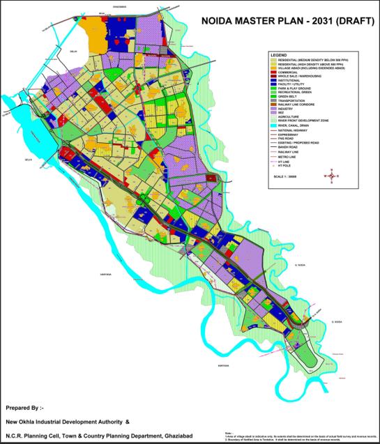 Noida Master Plan 2031
The Noida Master Plan 2031 PDF can be found on the official website of the New Okhla Industrial Development Authority (Noida) at https://noidaauthorityonline.in/en/article/master-plan-for-noida
Key Goals of Noida Master Plan 2031
The Noida Master Plan 2031 outlines key goals in five main areas:
1. Sustainable development: Prioritizing the balance between environmental preservation and urbanization by focusing on conserving natural resources and reducing carbon emissions.
2. Infrastructural development: Improving road and metro networks, as well as upgrading water and sewage systems.
3. Affordable housing: Constructing housing options for individuals in the low and middle-income bracket.
4. Industrial and commercial growth: Establishing industrial hubs, IT parks, and commercial centers to promote economic growth and generate employment opportunities.
5. Smart city initiatives: Enhancing digital infrastructure, including e-governance facilities, for improved city functioning and services.
Land Utilization in Noida
In Noida, the utilization of land is evident in two distinct patterns: urban area land use and rural area land use. The city's planned Integrated Industrial Township comprises three industrial phases- Industrial Area Phase I, Industrial Area Phase II, and Industrial Area Phase III. Alongside these industrial zones, numerous sectors have been developed to cater to urban requirements such as residential, commercial, recreational, institutional, and other facilities across a significant expanse of the township.
As the development in the township progresses, efforts have been made to preserve green spaces. Notable green areas include a golf course in Sector 38, another in Sector 54, and one spanning Sectors 14A, 15A, and 16A along the Yamuna River. Future plans include the establishment of additional recreational areas such as a sports complex in Sectors 21A, 79, 101, 104, and 150, as well as one in Sector 38A, opposite Sectors 28, 29, 37, and 44.
In contrast, the rural areas of Noida exhibit a different landscape characterized by rural communities coexisting with agricultural fields in the southern district of the city. Agriculture thrives in these regions owing to fertile soil and well-established irrigation systems. Additionally, there are plantations in certain areas, with a significant portion located north of Sultanpur village and a smaller section along the western bank of Noida Drain to the west of Shahdara village.
The harmonious coexistence of urban and rural land use in Noida reflects the city's balanced development approach, catering to both industrial growth and agricultural sustainability. The preservation of green spaces and agricultural lands alongside urban development showcases Noida's commitment to holistic land management and sustainable growth.
|
Land Use |
Description |
|
Urban Area Land Use |
|
|
Rural Area Land Use |
|
Maximizing Land Potential in Noida for Sustainability
Optimizing land usage is a crucial aspect of town development planning, influencing factors such as future town proportions, growth trajectories, and layout. Successful land use planning establishes clear guidelines and a timeline for the upcoming development of a defined region.
Noida, a rapidly expanding city, has exceeded the growth predictions set by previous Master Plans over the past decade. Analysis of current satellite imagery indicates that as of January 2010, approximately 9211 hectares of land have been developed for various purposes, with an additional 1000 hectares under development.
This rapid growth demonstrates that Noida's development has outpaced the projections outlined in the 2011 Master Plan. Originally revised in 2006 for the year 2021, this plan allocated 14964 hectares for urban development. A comparison with the projected Noida Master Plan 2021 reveals that approximately 61.61% of the total designated land has already been developed.
The continuous expansion and development of Noida highlights the need for strategic land use planning to ensure sustainable growth and efficient utilization of available resources. As the city evolves, it is essential to adapt and adjust urban development strategies to accommodate the increasing demands and opportunities for growth in a planned and organized manner.
Proposed Urban Land Use Strategy in Noida
The proposed urban land use strategy in Noida is centered around the development of a grid system based on sectors, with main thoroughfares arranged in a gridiron design that spans diagonally from the southwest to the northeast. These thoroughfares are interconnected by perpendicular highways, creating a well-structured layout that divides the area into several distinct parts to promote a cohesive and self-sufficient society.
The strategy focuses on strategically placing high-density residential areas near workplaces to facilitate convenience for residents. Additionally, there is a central commercial center and a well-distributed network of commercial hubs throughout the city. Subdistrict centers are thoughtfully located within specified residential catchment regions to cater to the diverse needs of residents.
Special attention is given to zoning certain areas for high-density group living, incorporating ample recreational and green spaces to enhance the quality of life for residents. A central park, along with essential public and semi-public amenities, is strategically positioned to extend linearly from north to south, serving as a central hub for community activities.
The Noida Master Plan 2031 also proposes the development of a railway station complex in the city's southwestern section, enhancing connectivity and accessibility for residents and visitors alike.
By the master plan for 2031, the total land proposed for planned urban development in Noida is 15,28,00,000 sq.m., representing an increase from the 14,96,40,000 sq.m. allocated in the master plan for 2021. This expansion reflects the city's commitment to sustainable and strategic urban planning to accommodate the growing population and evolving needs of its residents.
Here is the land use distribution in Noida as per the approved Master Plan for 2021 and the proposed Master Plan for 2031 in a table for a better understanding:
|
Land Use Category |
Area in (HA) |
Approved Master Plan 2021 (%) |
Area in (HA) |
Proposed Master Plan 2031 (%) |
|
Residential |
5334 |
35.85 |
5722.14 |
37.45 |
|
Commercial |
564 |
3.77 |
581.33 |
3.80 |
|
Industrial |
3001 |
20.05 |
2806.52 |
18.37 |
|
Public & Semi Public Facilities |
1219 |
8.15 |
1357.97 |
8.89 |
|
Transportation |
2211 |
14.78 |
1942.15 |
12.71 |
|
Recreational |
1513 |
10.12 |
2432.82 |
15.92 |
|
Agriculture |
1017.50 |
6.80 |
332.47 |
2.18 |
|
Water Body |
104.50 |
0.68 |
104.50 |
0.68 |
The proposed land-use distribution for the year 2031 follows a hierarchical order, with the total proposed urbanizable area of about 15,280 hectares being divided into various sectors.
Facilities are distributed throughout the town to cater to the diverse needs of the residents and ensure sustainable urban development.
Population Growth Dynamics in Noida
Noida, a burgeoning metropolitan center in India, has experienced a remarkable surge in population since its inception. Traditional mathematical methodologies have proven inadequate in accurately forecasting its growth trajectory over the past two decades.
The early estimations in the Noida Master Plan's initial iterations to predict the population figures for 2011 and 2021 ranged between 7 to 9 lakhs. However, the actual population of Noida as recorded in the 2010 census had already exceeded 10 lakhs, rendering the 12 lakh population target set for 2021 under the Noida Master Plan 2021 somewhat irrelevant.
In light of the population surpassing expectations, subsequent population projections for planning purposes have been primarily based on the allotment of residential land. The overarching goal is to see the physical development of Noida reach its fruition by 2021, with a vision that nearly all residential areas will be fully occupied by 2031.
The table below delineates the population figures derived from the Noida Master Plan 2031's projections concerning residential property commitments within the planned area and the anticipated growth of rural communities. This data underscores the dynamic transformation and evolution of Noida's demographic landscape, reflecting the city's rapid urbanization and the corresponding adjustments in population planning strategies.
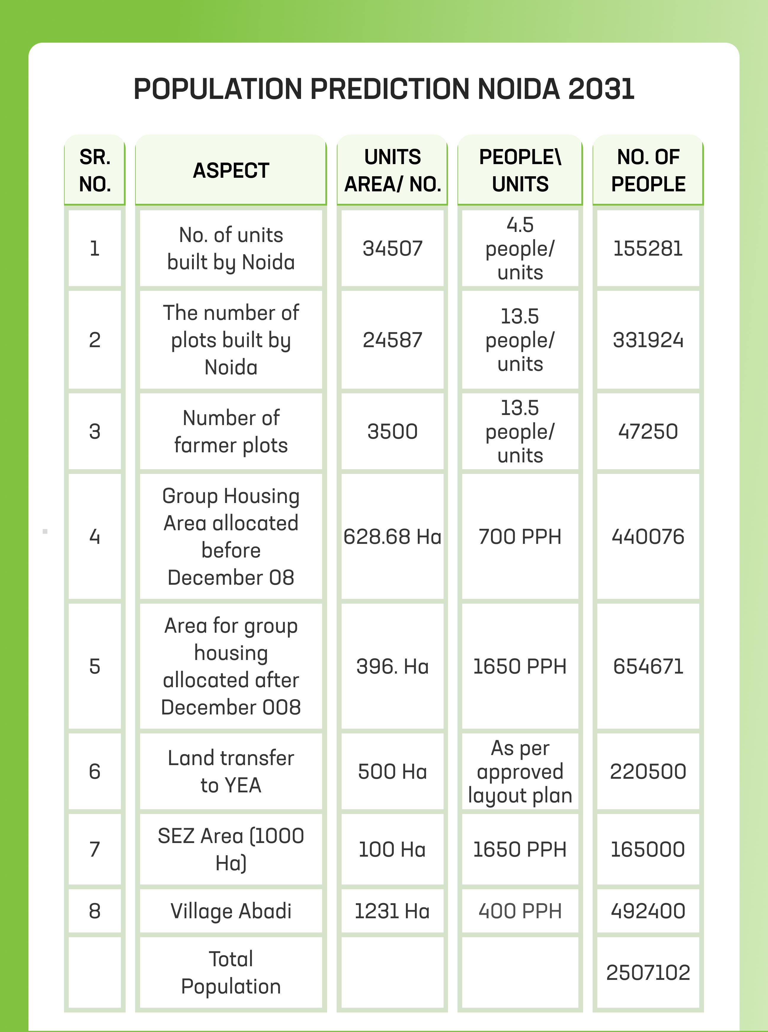 Population Prediction Noida 2031
According to the data, Noida's population is expected to reach 25 lakhs by the year 2031.
Population Density at Noida
The population of Noida is forecasted to exceed 25 lakhs by the year 2031, potentially reaching its maximum capacity. It is recognized that maintaining a high population density poses challenges in terms of geography and environment. To address this, the plan suggests that population density in established residential areas should remain below 500 people per hectare.
Noida has identified certain sectors for high-density housing, with designated areas earmarked for group housing developments that could accommodate up to 1650 individuals per hectare across approximately 400 hectares of land. This strategic approach by the Noida Authority aims to optimize the utilization of existing residential land while meeting the growing demand for affordable housing in the National Capital Region.
The city has strategically divided sectors into different population density categories, emphasizing a balanced approach to urban planning. Sectors 75, 74, 117, 118, 76, 77, 116, 115, 113, 112, 78, 107, 45, 168, 938, 86, 143, 144, 151, 162, and 158 are designated for maintaining a population density below 500 people per hectare, encompassing all other residential areas.
The Noida Master Plan 2031 envisions an urban population density of 164 people per hectare, aligning with the NCR Regional Plan 2021's goal of 150-200 persons per hectare for metropolitan cities. This density is deemed appropriate and sustainable for a city like Noida, considering its geographic constraints and environmental factors. By strategically managing population densities across different sectors, Noida aims to ensure a livable and functional urban environment for its residents as it progresses towards accommodating a larger population by 2031.
Land Use Planning Under Noida Master Plan 2031
The Noida Master Plan 2031 presents a comprehensive strategy for the distribution of land use in Noida, recognizing the city's planned expansion and economic focus on industrial development. With an allocated land area of approximately 20316 hectares, the Noida Authority is actively acquiring the necessary land for the city's anticipated growth.
A significant portion, around 25%, of the land area lies outside the Yamuna and Hindon river embankments, a flood-prone region deemed unsuitable for urbanization. This area is earmarked for riverfront development projects, aligning with the master plan's vision for sustainable land use practices.
Within the 15280 hectares of land situated between the river embankments, Noida plans to implement urban development initiatives to accommodate the city's expanding population and infrastructure needs. The master plan emphasizes leveraging this land for residential, commercial, and institutional purposes to create a well-rounded and thriving urban environment.
Noida's economic landscape is primarily driven by industrial activities, reflecting its origins as an industrial township. Initially intended to designate 20% of the land area for industrial use, the current plan reserves approximately 18.37% of the land for industrial activities by 2031, with minor adjustments to align with evolving economic and industrial demands.
The strategic allocation of land use under the Noida Master Plan 2031 underscores the city's commitment to sustainable development, balancing economic growth with environmental considerations, and the creation of vibrant urban spaces for its residents and stakeholders. As Noida continues to evolve and expand, the effective management of land use will be crucial in shaping the city's future trajectory.
Distribution of Land Use: Noida Master Plan 2031
|
S. No. |
Land Use |
Proposed for 2031 (Area in Ha) |
Percentage (%) |
|
1 |
Residential |
5722.14 |
37.45 |
|
2 |
Commercial |
581.33 |
3.80 |
|
3 |
Industrial |
2006.52 |
18.37 |
|
4 |
Public and semi-public facilities |
13557.91 |
8.89 |
|
5 |
Transportation |
1942.15 |
12.71 |
|
6 |
Recreational |
2432.82 |
15.92 |
|
7 |
Agricultural |
332.47 |
2.18 |
|
8 |
Water body |
104.50 |
0.68 |
|
Total |
- |
15789.90 |
100.00 |
What is Mixed Land Use?
The Noida Authority implemented a policy of mixed land use in the Noida Master Plan 2021, which permits a combination of residential and other activities within designated commercial zones situated along major roadways. Under this approach, retail business operations are confined to the ground floor, while residential activities are permitted on upper floors. This concept of mixed land use has been increasingly embraced in various locations due to its advantages and flexibility.
To optimize land utilization for diverse purposes and reduce the need for extensive transportation infrastructure, residential facilities are now allowed in commercial and institutional areas. The Noida Authority has also approved a mix of commercial, residential, and institutional activities on large residential or institutional plots located in different sectors. This strategic integration of functions aims to enhance convenience for residents, minimize travel requirements for employees, and promote efficient land utilization.
Although the Noida Master Plan 2031 currently does not delineate specific mixed land use areas, the Authority retains the flexibility to designate such plots for mixed land use schemes during the detailed layout planning of particular sectors or regions. This approach allows for adaptability and responsiveness to changing urban needs and demands in the evolving urban landscape of Noida.
Planned Regional Transport Connections
The strategic placement of Noida offers significant advantages in terms of connectivity, as it sits at a crucial juncture linking Ghaziabad and the Delhi Urban Area. Recognizing the potential benefits derived from this advantageous location, there is now a proposal for the development of a comprehensive regional transportation network encompassing both rail and road infrastructure.
This proposed regional transportation link aims to enhance connectivity between Noida, Ghaziabad, and the broader Delhi Urban Area, facilitating the seamless movement of goods, services, and people across these key regions. The integration of rail and road networks is envisioned to streamline transportation and optimize accessibility, offering efficient travel options for residents, commuters, and businesses operating within and around Noida.
By leveraging Noida's strategic position and establishing robust regional transportation links, the authorities seek to promote economic growth, spur development, and foster greater regional integration. This initiative not only enhances connectivity within the broader metropolitan area but also reinforces Noida's position as a pivotal hub for commerce, trade, and urban development in the National Capital Region (NCR).
 Noida Transportation
Planned Regional Railway Connections
A key component of the proposed multimodal transport system for Noida involves the development of regional rail linkages to enhance connectivity and facilitate efficient transportation within and around the city. One significant railway project in the pipeline is the construction of a railway line connecting Dadri in the east to Tughlakabad in the southwest of Delhi, with Noida serving as a crucial junction along this route. The plan entails the establishment of strategic locations for railroad yards and stations near the village of Chaprauli, aimed at optimizing the operational efficiency and accessibility of the rail network.
In addition, Noida stands to benefit from the Mumbai-Delhi dedicated rail freight corridor, which is set to traverse through the city. As part of this transformative initiative, a proposed rail route cutting through sectors 160 and 146 has been outlined to support the seamless movement of freight within Noida and beyond. Sector 160 is earmarked for the development of a dedicated railway station, a rail freight yard, and a state-of-the-art logistics park to cater to the escalating demands of freight transportation in Noida. By strategically positioning these facilities in key sectors, the authorities aim to optimize the logistical capabilities of Noida and bolster its status as a vital logistics hub in the region, further enhancing its economic growth and regional connectivity.
Metro Corridor
The existing Metro services linking Delhi and Noida City Center have significantly enhanced the accessibility and convenience of commuting between these two prominent locations. Presently, Metro stations are operational in key sectors such as -15, 16, 18, 38A, 38, and 32, catering to the transportation needs of residents and visitors in these areas. However, recognizing the growing demand for efficient public transport solutions, Noida and Greater Noida Authority have set forth ambitious plans to expand the Metro network further.
One major undertaking on the horizon is the proposed extension of the Metro Service from City Center Noida to Bodaki Railway Station in Greater Noida via Pari-Chowk. This expansion project is poised to connect important nodes within the region and enhance connectivity for commuters traveling between Noida and Greater Noida. Along this new Metro corridor, plans are in place for the construction of 14 new stations in strategic locations to ensure optimal coverage and accessibility for residents across Noida.
 Noida Metro
Moreover, in line with the vision for a comprehensive and integrated public transport system, the Delhi Metro Rail Corporation (DMRC) and Noida Authority are exploring additional Metro service links as part of the third phase of development. Two potential connections have been identified for further expansion.
The first proposed link would connect Delhi's Botanical Garden to Sarita Vihar via Kalindi Kunj, opening up new connectivity options and easing travel for residents along this route. The second envisioned connection extends from the City Center to NH-24 and facilitates seamless travel between the City Centre and Greater Noida through Sector 121, addressing the evolving mobility needs of commuters and enhancing overall connectivity within Noida and its surrounding areas.
By proactively planning and implementing these Metro expansion projects, Noida is poised to further bolster its public transport infrastructure and reinforce its reputation as a well-connected and commuter-friendly city in the National Capital Region.
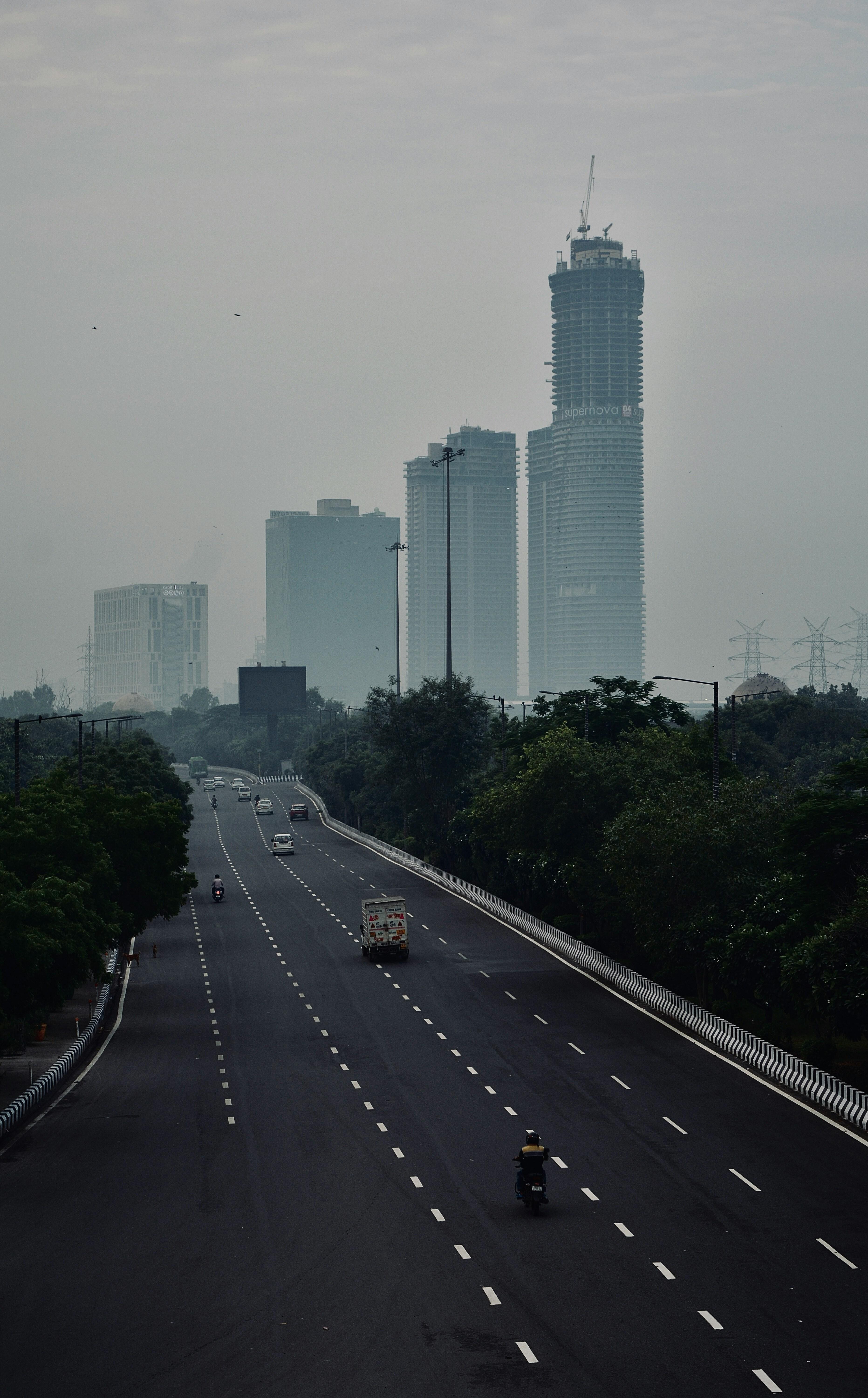
Planned Regional Road Connections
In a bid to strengthen regional connectivity and bolster the transportation network in Noida, significant emphasis has been placed on developing key road links that seamlessly link the city to its neighboring regions. Among the proposed regional road links, two crucial routes have surfaced as pivotal components in enhancing Noida's accessibility and connectivity.
The first proposed route entails the construction of an expressway that will serve as a vital link between Noida and Greater Noida. This expressway is designed to streamline travel between these two bustling urban centers, promoting smoother and quicker commutes for residents, workers, and visitors traversing between the two cities. By establishing this direct connection, the expressway aims to alleviate traffic congestion and enhance overall transport efficiency within the region.
Moreover, as part of the multimodal corridor development plan, another significant road link has been proposed to interconnect Noida with Faridabad in the south and Ghaziabad in the north. This ambitious project envisions a roadway network that will facilitate seamless travel between these prominent cities, fostering greater regional integration and promoting economic development across the interconnected urban areas.
 Noida Roads
One key highlight of the proposed road infrastructure is the planned construction of a new road link between Noida and Faridabad, aimed at connecting NH-2 to the Noida-Greater Noida Expressway in the vicinity of Noida's sectors 150 and 152. This strategic link is poised to enhance connectivity and accessibility for commuters traveling along these corridors, offering a more efficient and convenient route for intercity travel.
Furthermore, plans are underway to develop a planned 120-meter-wide road in Greater Noida Phase II, which will serve as a crucial connector between NH-2, Noida, Greater Noida, NH-91, and eventually link up with NH-24 near Hapur. This comprehensive road network is envisioned to bolster regional connectivity, facilitate smoother transportation flow, and support the economic and infrastructural growth of Noida and its adjoining regions.
By strategically investing in and advancing these proposed road infrastructure projects, Noida is poised to strengthen its position as a well-connected urban hub and enhance the overall quality of life for its residents and visitors through improved transportation solutions.
New Noida Master Plan 2041
The Noida Authority has recently approved the draft plan for the New Noida Master Plan 2041, signaling a significant expansion in the region. In this proposed plan, the authority aims to acquire approximately 21,000 hectares of land to facilitate the development of industries and establish a modern industrial hub within the Dadri-Noida-Ghaziabad Investment Region (DNGIR), which falls under the purview of New Noida.
The primary objective of the plan is to create special economic zones tailored for industrial units operating in sectors such as agriculture, food processing, and FMCG. Additionally, the master plan includes provisions for the construction of integrated townships, knowledge centers, skill development facilities, and logistics hubs. Inspired by urban models from cities like Chicago in the United States and European counterparts, the plan envisions the development of eighty-four villages in Dadri and Bulandshahar.
The proposed New Noida township will cover an expansive area of 20,000 hectares, comprising 41 designated zones for industrial activities. Allocation of land use in the township includes 11.5% for residential purposes, 17% for green spaces and recreational areas, 15.5% for road infrastructure, 9% for institutional facilities, and 4.5% for commercial establishments, outlining a comprehensive approach to urban development and industrial expansion in the region.
|
Aspect |
Details |
|
Land Acquisition |
Approximately 21,000 hectares planned |
|
Industrial Development |
Creation of special economic zones for agriculture, food processing, and FMCG sectors |
|
Township Development |
Integrated townships, knowledge centers, skill development facilities, and logistics hubs planned |
|
Village Development |
84 villages in Dadri and Bulandshahar to be developed along urban models like Chicago |
|
Township Area |
20,000 hectares |
|
Land Use Allocation |
|
Conclusion
The article provides an in-depth exploration of the past, present, and future urban planning initiatives in Noida, focusing on the Noida Master Plans for 2031 and the draft plan for New Noida Master Plan 2041. Noida, as a vital component of the National Capital Region, has evolved into a vibrant economic and industrial hub, demonstrating a balanced approach to development that integrates urbanization with environmental sustainability.
The Noida Master Plan 2031 sets out key goals for sustainable, infrastructural, affordable housing, industrial, and smart city development. The distribution of land use under the 2031 plan showcases a strategic allocation for residential, commercial, industrial, public facilities, transportation, recreational, agricultural, and water bodies. The plan emphasizes efficient land utilization while accommodating the growth of the city's population and infrastructure needs.
Looking ahead, the New Noida Master Plan 2041 introduces ambitious proposals to expand industrial development and establish a modern industrial hub within the Dadri-Noida-Ghaziabad Investment Region. The plan envisions the creation of special economic zones, integrated townships, and infrastructure facilities, reflecting innovative urban models and sustainable land management practices.
Overall, the strategic and forward-thinking approach outlined in both master plans signifies Noida's commitment to sustainable development, economic growth, and enhanced quality of life for its residents. As Noida continues to evolve and grow, these comprehensive plans aim to shape the city's future trajectory, fostering a dynamic urban environment and positioning it as a key player in the region's economic landscape.
explore further
Latest from Editorials
More from Publications
Resources


Dwello, for every home buyer, is a way to go from 'I feel' to 'I know', at no extra cost.