


Table of Contents
- Mumbai-Pune Expressway (NH 48):
- Map of NH 48
- Key Points of Mumbai-Pune Expressway (NH48)
- Pune-Solapur Highway (NH 65)
- Routes through Pune
- Map of NH 65
- Key Points of NH 65
- Pune-Nashik Highway (State Highway 60)
- Map of Pune Nashik Highway
- Key Points of National Highway 60
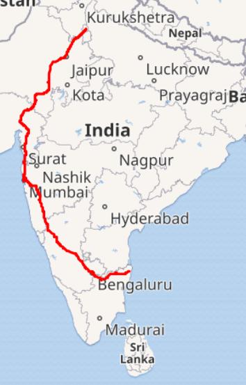
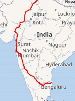
- Pune-Bengaluru Highway (NH 48):
- Map of Pune-Bengaluru Highway
- Key Points of Pune-Bengaluru Highway
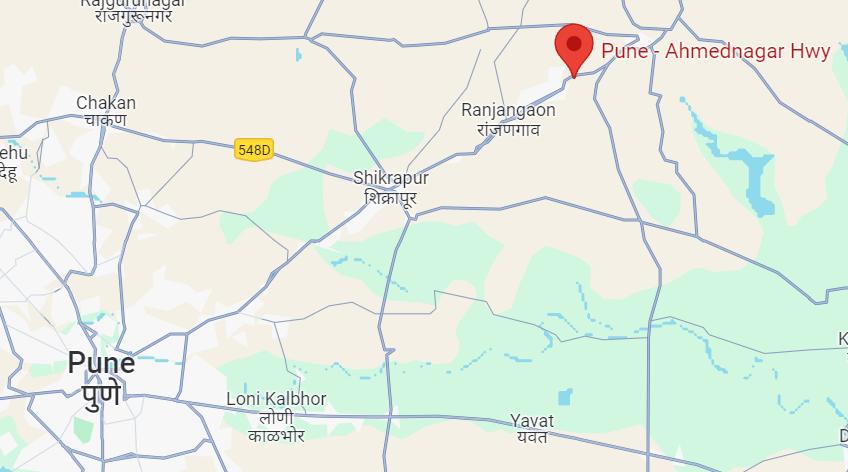
- Pune-Ahmednagar Highway/ State Highway 27:
- Map of Pune-Ahmednagar Highway
- Key Points of Pune-Ahmednagar Highway
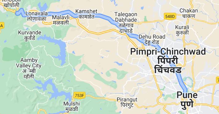
- Pune-Mumbai Highway (Old Highway):
- Map of Pune-Mumbai Old Highway
- Key Points of Old Pune-Mumbai Highway:
- Faq's
Pune, often referred to as the Oxford of the East is a vibrant city located in the western Indian state of Maharashtra. Known for its rich history, educational institutions, and growing IT industry, Pune is also a bustling urban center with a well-developed road network. Highways play a crucial role in connecting Pune to other major cities and towns, facilitating transportation and commerce.
Pune has excellent road connectivity to various cities and states in the country. Pune has both private and public transport available for commuters.
Pune is easily accessible from various cities and states across the country. National Highway 48 links Pune to Mumbai, Kolhapur, and Bangalore, while State Highway 60 leads to Nashik. State highways also connect Pune to Aurangabad, Ahmednagar, and Alandi. Within the city, the most important routes include parts of NH 48 and the old Pune-Mumbai Highway.
To reach Pune from other cities, one can prefer the national highways or the state highways.
In this article, we will look into the list of highways in Pune, highlighting their significance and impact on the city.
Mumbai-Pune Expressway (NH 48):
The Mumbai-Pune Expressway, originally a segment of NH 48 (formerly NH 4), is commonly referred to as the Old Mumbai-Pune Road subsequent to the inauguration of the Mumbai-Pune Expressway in 2002.
It commences in the suburban area of Shivajinagar, previously known as Bhamburde, and traverses through various suburbs including Khadki Cantonment, Bopodi, Dapodi, Kasarwadi, Pimpri, Chinchwad, Nigdi, Dehu Road Cantonment, Kivale, Mamurdi, Gahunje, Talegaon Dabhade, and Vadgaon Maval before reaching Mumbai. Spanning approximately 156 kilometers from Pune to Mumbai, this route holds significance for its historical, cultural, and practical aspects.
Along its course, notable landmarks include the College of Agriculture in Shivajinagar, the College of Military Engineering in Dapodi, and Appu Ghar in Nigdi. Moreover, the Old Mumbai-Pune Road serves as one of the routes frequented by devotees undertaking the pilgrimage to Pandharpur during the Pandharpur Wari festival, adding to its cultural importance.
In summary, this road, integral to NH 48, bears the legacy of connecting Pune and Mumbai and continues to serve as a vital artery for commuters, pilgrims, and travelers alike, while also being rich in historical and cultural significance.
Stretching over 94.5 kilometers, this six-lane expressway connects Mumbai, the financial capital of India, with Pune. Opened to the public in 2002, the expressway significantly reduced travel time between the two cities, making it a vital lifeline for commuters, tourists, and freight transportation.
Also Read: List Of Key Expressways & National Highways Connecting Delhi
Map of NH 48
Source: Wikipedia
Key Points of Mumbai-Pune Expressway (NH48)
Length: 94.5 kilometers.
Importance: Vital link between Mumbai and Pune, reducing travel time significantly.
Impact: Facilitates smooth movement of commuters, tourists, and freight, boosting economic activities between the two cities.
Features: Six-lane expressway with modern infrastructure, including service lanes, emergency facilities, and toll plazas.
Operational Since: 2002.
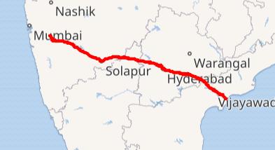
Pune-Solapur Highway (NH 65)
National Highway 65 (NH 65), formerly known as National Highway 9, is a significant roadway in India traversing through multiple states, including Maharashtra, Karnataka, Telangana, and Andhra Pradesh.
Stretching from Pune to Machilipatnam, NH 65 passes through several major cities, including Pune, Solapur, Hyderabad, Suryapet, Vijayawada, and Machilipatnam
The segment between Hyderabad and Vijayawada is recognized as the Vijayawada-Hyderabad Expressway. This expressway section is pivotal in facilitating rapid and efficient transportation between Hyderabad and Vijayawada, two significant cities in Telangana and Andhra Pradesh.
One of the unique things about this highway is that it passes through regions rich in cultural heritage and historical significance and serves as a conduit for cultural exchange and pilgrimage, with travelers journeying to various destinations of religious and historical importance along the route.
Source: Wikipedia
Routes through Pune
- Pune
- Hadapsar (Suburb of Pune)
- Loni Kalbhor
- Bhigwan
- Indapur
- Tembhurni
- Mohol
- Solapur
- Naldurg
- Yenegur
- Omerga
Also Read: Popular Localities in Ring Road, Pune
Map of NH 65
Source: Wikipedia
Key Points of NH 65
Route and Length: NH 65 is approximately 246 kilometers and spans across multiple states, including Maharashtra, Karnataka, Telangana, and Andhra Pradesh.
Significance: Connects Pune with Solapur, fostering regional connectivity and trade.
Role: Critical route for passenger and cargo traffic, linking industrial areas and towns along the corridor.
Starts From: Pune
Ends: Machilipatnam
Impact: NH 65 plays a crucial role in facilitating the movement of goods and services, thereby stimulating economic growth and development in the regions it traverses
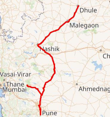
Pune-Nashik Highway (State Highway 60)
The Pune-Nashik Highway, designated a State Highway 60 (and NH 60), serves as a vital link between Pune and Dhule in Maharashtra, India. Previously known as NH 3 and NH 50, NH 60 covers a total distance of 360.6 kilometers. Notably, the segment from Dhule to Nashik forms a part of Asian Highway 47, enhancing its significance in regional and international connectivity.
NH 60 traverses through various towns and cities in Maharashtra, including Dhule, Arvi, Malegaon, Saundane, Chandwad, Ojhar, Nashik, Sinnar, Sangamner, Alephata, Bota, Pimpalwandi, Narayangaon, Peth, Khed, Chakan, and Pune. This extensive route facilitates transportation and connectivity across the state, promoting economic activities, trade, and tourism.
Map of Pune Nashik Highway
Source: Wikipedia
Also Read: List of Highways and National Highways in Mumbai
Key Points of National Highway 60
Route and Length: The total length of NH 60 is 360.6 kilometers (224.1 miles).
Previous Designations: Previously known as NH 3 and NH 50
Impact: NH 60 facilitates the movement of goods, services, and people, contributing to economic activities along its route.
Infrastructure: The highway features modern infrastructure including roadways, bridges, and amenities to ensure safe and efficient transportation for commuters and travelers.
Connectivity: NH 60 enhances connectivity between Pune and Dhule, providing a vital transportation link for commuters, traders, and tourists.
Pune-Bengaluru Highway (NH 48):
Also a part of the NH 48, The Pune-Bengaluru Highway connects Pune with Bengaluru, the capital city of Karnataka and a major IT hub in India. This highway covers a distance of approximately 841 kilometers, traversing through Maharashtra, Karnataka, and Andhra Pradesh.
The Pune-Bengaluru Highway serves as a significant link between Pune and Bengaluru, two major cities known for their economic importance, educational institutions, and IT industry. It enables seamless connectivity between the western and southern regions of India, fostering trade, tourism, and cultural exchange.
NH 48 is a well-maintained, multi-lane highway that ensures smooth and efficient transportation for commuters, tourists, and cargo vehicles traveling between Pune and Bengaluru. Also along its route, the Pune-Bengaluru Highway connects several industrial hubs, manufacturing centers, and agricultural regions. This facilitates the transportation of goods and raw materials, supporting economic activities and regional development.
Map of Pune-Bengaluru Highway
Source: Wikipedia

Source: Wikipedia
Key Points of Pune-Bengaluru Highway
Length: The exact distance may vary depending on the route taken, but it typically ranges around 800 kms
Route: The highway passes through various towns, cities, and regions in Maharashtra and Karnataka. It traverses through important cities like Satara, Kolhapur, Belagavi (Belgaum), and Hubballi (Hubli), among others. The route offers travelers glimpses of diverse landscapes, including plains, hills, and agricultural fields.
Tourism and Sightseeing: The highway passes through regions with cultural and natural attractions, offering opportunities for tourism and sightseeing. Travelers can explore historical landmarks, scenic spots, and cultural heritage sites located along the route.
Transport Infrastructure: The Pune-Bengaluru Highway is equipped with modern transport infrastructure, including service roads, rest areas, fuel stations, and toll plazas. These facilities ensure convenience and safety for travelers during their journey.
Also Read: Key Expressways, National & State Highways Connecting Bengaluru
Pune-Ahmednagar Highway/ State Highway 27:
The Pune-Ahmednagar Highway is a key road connecting Pune and Ahmednagar in Maharashtra. Starting from Yerawada in Pune, it passes through areas like Vadgaon Sheri, Kharadi, and Wagholi before reaching Ahmednagar. Along the way, you will find important places like Pune International Airport and EON Free Zone. This highway is crucial for both commuters and businesses, offering a faster way to travel between the two cities compared to trains.
Known officially as State Highway 27, this highway is preferred by many because it takes only about two hours to reach Ahmednagar from Pune, while trains typically take four hours. The road is well-maintained and plays a significant role in connecting people and businesses, contributing to the economic growth of the region.
Map of Pune-Ahmednagar Highway
Key Points of Pune-Ahmednagar Highway
Route: It connects the city of Pune in Maharashtra to Ahmednagar, forming a crucial transportation link between these two urban centers.
Importance: Serving as a vital corridor, the Pune-Ahmednagar Highway facilitates the movement of goods and people between Pune and Ahmednagar, contributing to regional connectivity and economic development.
Connectivity: The highway enhances accessibility to major areas in Pune and Ahmednagar, as well as surrounding regions, supporting daily commutes and commercial activities.
Lanes: Comprising multiple lanes in both directions, the Pune-Ahmednagar Highway accommodates heavy traffic flow, ensuring smoother and faster travel between the two cities.
Maintenance: Regular maintenance and upkeep of the highway are undertaken by the Maharashtra State Road Development Corporation (MSRDC) or relevant authorities to ensure safety and efficiency for commuters.
Pune-Mumbai Highway (Old Highway):
Before the construction of the Mumbai-Pune Expressway, The Old Pune-Mumbai Highway was a significant roadway and still continues to be traversing through Pune, India.
Beginning at Shivaji Nagar in the city center and concluding at Dehu Road, it spans various regions including Pune and Pimpri-Chinchwad, with notable intersections at Khadki and Dehu Road cantonment board borders.
In contrast, the Mumbai-Pune Expressway stands as a pioneering 6-lane concrete toll expressway, connecting Pune, a hub of culture and education, with Mumbai, the financial capital.
Constructed predominantly with concrete, the expressway boasts 4-6 lanes within Pune and 8-10 lanes in Pimpri-Chinchwad, running parallel to the railway line for approximately 27 kilometers.
Notably, the New Mumbai Pune Highway Toll Road aligns closely with the Old Mumbai Pune Highway, intersecting and diverging at Lonavala and Khandala districts. Additionally, within Pune, the Old Pune Highway branches into the Nasik-Pune and Talegaon-Dabhade highways at different junctures.
Map of Pune-Mumbai Old Highway
Key Points of Old Pune-Mumbai Highway:
Length: The Old Pune-Mumbai Highway spans approximately 27 kilometers, offering a significant stretch of road connecting urban centers.
Connectivity: It serves as a crucial link between Pune and Mumbai, two major cities in Maharashtra, facilitating the movement of goods and people between them.
Lane Configuration: The highway features varying lane configurations, with 4-6 lanes within the municipal limits of Pune and 8-10 lanes within the municipal limits of Pimpri Chinchwad.
Parallel Routes: The New Mumbai Pune Highway Toll Road runs almost parallel to the Old Mumbai Pune Highway, providing additional options for commuters.
In a nutshell, The highways of Pune keep the city connected and thriving. They are not just roads, they are pathways to opportunities, connecting commuters to other cities, cultures, and economies. As Pune grows, so will the importance of these highways, ensuring that the city remains a hub of activity and innovation.
explore further
Latest from Editorials
More from Publications
Resources


Dwello, for every home buyer, is a way to go from 'I feel' to 'I know', at no extra cost.